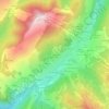
Morzine topographic map
Click on the map to display elevation.
Morzine
A traditional market town in the heart of the Portes du Soleil, Morzine is dominated by chalets spread across a river gorge, bordered by partially wooded slopes allowing skiing in poor weather conditions. Situated at an altitude of about 1,000 m, it is one of the most northerly of the French Alpine resorts, weatherwise benefiting from the Mont Blanc microclimate. The locality enjoys panoramic mountain views and modern ski facilities, as well as hotels and restaurants in the town itself. The ski resort of Avoriaz is located on the territory of the commune.
About this map
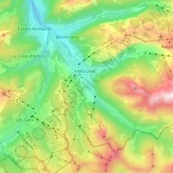
Name: Morzine topographic map, elevation, terrain.
Average elevation: 4,577 ft
Minimum elevation: 2,795 ft
Maximum elevation: 7,795 ft
Other topographic maps
Click on a map to view its topography, its elevation and its terrain.
Aiguille du Midi
France > Auvergne-Rhône-Alpes > Upper Savoy > Chamonix-Mont-Blanc
Average elevation: 10,161 ft
Les Bossons
France > Auvergne-Rhône-Alpes > Upper Savoy > Chamonix-Mont-Blanc
Average elevation: 4,514 ft
Chamonix-Mont-Blanc
France > Auvergne-Rhône-Alpes > Upper Savoy > Chamonix-Mont-Blanc > Chamonix-Mont-Blanc
Average elevation: 5,863 ft
Aiguille Verte
France > Auvergne-Rhône-Alpes > Upper Savoy > Chamonix-Mont-Blanc
Average elevation: 10,577 ft
La Vendanche
France > Auvergne-Rhône-Alpes > Upper Savoy > Le Grand-Bornand
Average elevation: 4,596 ft
Le Blanc Chat
France > Auvergne-Rhône-Alpes > Upper Savoy > Épagny Metz-Tessy
Average elevation: 1,598 ft