Geolocate

Liberty topographic map

Click on the map to display elevation.

About this map

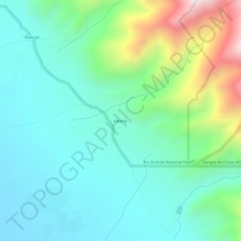
Name: Liberty topographic map, elevation, terrain.

Location: Liberty, Saguache County, Colorado, United States (37.84028 -105.61584 37.88028 -105.57584)

Average elevation: 8,573 ft

Minimum elevation: 7,828 ft

Maximum elevation: 10,830 ft

Saguache County trails, hiking, mountain biking, running and outdoor activities

Other topographic maps

Click on a map to view its topography, its elevation and its terrain.

Center

United States > Colorado > Saguache County

Average elevation: 7,648 ft

Continental Divide

United States > Colorado > Saguache County

Average elevation: 11,854 ft

Bonanza

United States > Colorado > Saguache County

Average elevation: 9,974 ft

Gear up for your next adventure:

🧣Merino Neck Gaiters - Multi-functional headwear for wind and sun protection
🧴Hand Sanitizer - Keep hands clean while hiking
Backpacking Tents - Weight-optimized shelters for multi-day topographic surveys
🧭Hiking Compass - Precision compass for reliable navigation in the wilderness
🌡️Portable Weather Meter - Track weather conditions on the trail

As an Amazon Associate, this site earns from qualifying purchases at no extra cost to you.