Geolocate

Lacchiarella topographic map

Click on the map to display elevation.

About this map

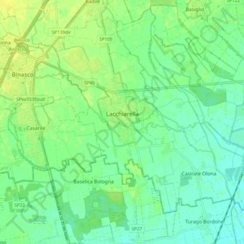
Name: Lacchiarella topographic map, elevation, terrain.

Location: Lacchiarella, Milan, Lombardy, 20084, Italy (45.28921 9.11196 45.34954 9.20321)

Average elevation: 312 ft

Minimum elevation: 285 ft

Maximum elevation: 344 ft

Other topographic maps

Click on a map to view its topography, its elevation and its terrain.

Monte Stella

Italy > Lombardy > Milan > Milan

Average elevation: 440 ft

Castelletto di Cuggiono

Italy > Lombardy > Milan

Average elevation: 466 ft

Fagnano

Italy > Lombardy > Milan > San Vito

Average elevation: 394 ft

Zivido

Italy > Lombardy > Milan > San Giuliano Milanese

Average elevation: 308 ft

Ospiate

Italy > Lombardy > Milan > Bollate

Average elevation: 512 ft

Mazzo

Italy > Lombardy > Milan > Rho

Average elevation: 509 ft

Cascina Confaloniera

Italy > Lombardy > Milan > Rosate

Average elevation: 351 ft

Mariotto

Italy > Lombardy > Milan > San Colombano al Lambro

Average elevation: 203 ft

Pantanedo

Italy > Lombardy > Milan > Rho > Mazzo

Average elevation: 502 ft

San Pietro all'Olmo

Italy > Lombardy > Milan > Cornaredo

Average elevation: 466 ft

Vaiano Valle

Italy > Lombardy > Milan > Milan > Vaiano Valle

Average elevation: 361 ft

Gear up for your next adventure:

📚Navigation Handbooks - Master the art of reading topographic maps and using a compass
🌡️Handheld Weather Meters - Measure wind, temp, and pressure for safe mountain travel
🪶Thermal Camp Blanket - Extra warmth for cold nights
🔦LED Headlamp - Bright and durable LED headlamp for night navigation
🏕️Family Camping Gear - Essentials for group camping trips

As an Amazon Associate, this site earns from qualifying purchases at no extra cost to you.