Geolocate

Lindsay topographic map

Click on the map to display elevation.

About this map

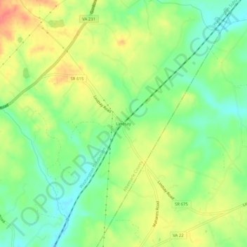
Name: Lindsay topographic map, elevation, terrain.

Location: Lindsay, Albemarle County, Virginia, United States (38.06819 -78.26639 38.10819 -78.22639)

Average elevation: 505 ft

Minimum elevation: 417 ft

Maximum elevation: 614 ft

Other topographic maps

Click on a map to view its topography, its elevation and its terrain.

Crozet

United States > Virginia > Albemarle County > Crozet

Average elevation: 682 ft

Free Union

United States > Virginia > Albemarle County > Free Union

Average elevation: 518 ft

Keswick

United States > Virginia > Albemarle County > Keswick

Average elevation: 417 ft

Rio

United States > Virginia > Albemarle County > Rio

Average elevation: 489 ft

Scottsville

United States > Virginia > Albemarle County

Average elevation: 377 ft

Ivy

United States > Virginia > Albemarle County

Average elevation: 614 ft

Rio

United States > Virginia > Albemarle County > Rio

Average elevation: 489 ft

Lake

United States > Virginia > Albemarle County > Hollymead

Average elevation: 495 ft

Crozet

United States > Virginia > Albemarle County > Crozet

Average elevation: 682 ft

Gear up for your next adventure:

🪶Multi‑Purpose Knife - Useful blade for camp and trail
🥘Titanium Cookware - Durable, featherlight pots and pans for backpacking
🧢Sun Protection Hats - Wide-brimmed and UPF-rated hats for high-altitude sun safety
🦶Hiking Gaiters - Keep debris and water out of your boots
🌡️Portable Weather Meter - Track weather conditions on the trail

As an Amazon Associate, this site earns from qualifying purchases at no extra cost to you.