
Make a donation
Gear up for your next adventure:
As an Amazon Associate, this site earns from qualifying purchases at no extra cost to you.
Kanchipuram topographic map
Click on the map to display elevation.
Make a donation
Gear up for your next adventure:
As an Amazon Associate, this site earns from qualifying purchases at no extra cost to you.
Kanchipuram
Kanchipuram is located at 12°59′N 79°43′E / 12.98°N 79.71°E / 12.98; 79.71, 72 km (45 mi) south-west of Chennai on the banks of the Vegavathi River, a tributary of the Palar River. The city covers an area of 11.6 km2 (4.5 sq mi) and has an elevation of 83.2 m (273 ft) above sea level.The land around Kanchipuram is flat and slopes towards the south and east. The soil in the region is mostly clay, with some loam, clay, and sand, which are suitable for use in construction. The Chingleput District Manual (1879) describes the region's soils as "highly inferior" and "highly stony or mixed with lime, gravel, soda and laterite". It has been postulated that the granite required for the Varadaraja Perumal Temple might have been obtained from the Sivaram Hills located 10 miles east of Kanchipuram. The area is classified as a Seismic Zone II region, and earthquakes of up to magnitude 6 on the Richter Scale may be expected. Kanchipuram is subdivided into two divisions – Big Kanchi, also called Shiva Kanchi occupies the western portion of the city and is the larger of the two divisions. Little Kanchi, also called Vishnu Kanchi, is located on the eastern fringes of the city. Most of the Shiva temples lie in Big Kanchi while most of the Vishnu temples lie in Little Kanchi.
Make a donation
Gear up for your next adventure:
As an Amazon Associate, this site earns from qualifying purchases at no extra cost to you.
About this map
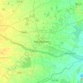
Name: Kanchipuram topographic map, elevation, terrain.
Average elevation: 269 ft
Minimum elevation: 141 ft
Maximum elevation: 614 ft
Make a donation
Gear up for your next adventure:
As an Amazon Associate, this site earns from qualifying purchases at no extra cost to you.
Other topographic maps
Click on a map to view its topography, its elevation and its terrain.
Dharapuram
India > Tamil Nadu > Dharapuram
Dharapuram is located at 10°44′N 77°31′E / 10.73°N 77.52°E / 10.73; 77.52. Dharapuram town is situated along of the bank of Amaravathi River which flows from the south to north. Uppar River and dam, Nallathankal River and dam, Palar join the river Amaravathi. It has an average elevation of 245…
Average elevation: 827 ft
Make a donation
Gear up for your next adventure:
As an Amazon Associate, this site earns from qualifying purchases at no extra cost to you.
Tiruvannamalai
India > Tamil Nadu > Tiruvannamalai
Tiruvannamalai is situated 196 km (122 mi) from the state capital Chennai and 210 km (130 mi) from Bangalore. The height of the Annamalai hill is approximately 2,669 ft (814 m). Tiruvannamalai is located at 12°00′N 79°03′E / 12°N 79.05°E / 12; 79.05. It has an average elevation of 200 metres…
Average elevation: 663 ft
Make a donation
Gear up for your next adventure:
As an Amazon Associate, this site earns from qualifying purchases at no extra cost to you.
Vellore
Yelagiri is a hill station located in Tirupattur district of the Vaniyambadi-Tirupattur road at an altitude of 1,410.6 metres above mean sea level and spread across 30 km2.
Average elevation: 1,145 ft
Ramanathapuram
India > Tamil Nadu > Ramanathapuram
Ramanathapuram is located at 9°23′N 78°50′E / 9.38°N 78.83°E / 9.38; 78.83. It has an average elevation of 2 metres (6 feet). The nearest towns include Paramakudi, Rameshwaram, Mudukulathur, Kilakarai and Manamadurai.
Average elevation: 23 ft
Make a donation
Gear up for your next adventure:
As an Amazon Associate, this site earns from qualifying purchases at no extra cost to you.
Thiruvilliputtur state assembly constituency
India > Tamil Nadu > Srivilliputhur
Average elevation: 1,053 ft
Make a donation
Gear up for your next adventure:
As an Amazon Associate, this site earns from qualifying purchases at no extra cost to you.
St.Thomas Mount-Pallavaram Cantonment Board
India > Tamil Nadu > Alandur > St.Thomas Mount-Pallavaram Cantonment Board
Average elevation: 43 ft
Make a donation
Gear up for your next adventure:
As an Amazon Associate, this site earns from qualifying purchases at no extra cost to you.
Make a donation
Gear up for your next adventure:
As an Amazon Associate, this site earns from qualifying purchases at no extra cost to you.
Make a donation
Gear up for your next adventure:
As an Amazon Associate, this site earns from qualifying purchases at no extra cost to you.
Make a donation
Gear up for your next adventure:
As an Amazon Associate, this site earns from qualifying purchases at no extra cost to you.
Make a donation
Gear up for your next adventure:
As an Amazon Associate, this site earns from qualifying purchases at no extra cost to you.
Make a donation
Gear up for your next adventure:
As an Amazon Associate, this site earns from qualifying purchases at no extra cost to you.