
Make a donation
Gear up for your next adventure:
As an Amazon Associate, this site earns from qualifying purchases at no extra cost to you.
Bogor topographic map
Click on the map to display elevation.
Make a donation
Gear up for your next adventure:
As an Amazon Associate, this site earns from qualifying purchases at no extra cost to you.
Bogor
The city is situated in the western part of Java island, about 53 km south of the capital Jakarta and 85 km northwest of Bandung, the administrative center of West Java Province. Bogor spreads over a basin near volcanoes Salak, which peaks at about 12 km south, and Mount Gede whose top is 22–25 km south-east of the city. The average elevation is 265 meters, maximum 330 m, and minimum 190 meters above sea level. The terrain is rather uneven: 17.64 km2 of its area has slopes of 0–2°, 80.9 km2 from 2° to 15°, 11 km2 between 15° and 25°, 7.65 km2 from 25° to 40° and 1.20 km2 over 40°; the northern part is relatively flat and the southern part is more hilly.
Make a donation
Gear up for your next adventure:
As an Amazon Associate, this site earns from qualifying purchases at no extra cost to you.
About this map
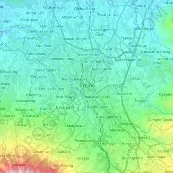
Name: Bogor topographic map, elevation, terrain.
Location: Bogor, West Java, Java, Indonesia (-6.68131 106.73484 -6.51433 106.84856)
Average elevation: 1,017 ft
Minimum elevation: 423 ft
Maximum elevation: 3,757 ft
Make a donation
Gear up for your next adventure:
As an Amazon Associate, this site earns from qualifying purchases at no extra cost to you.
Other topographic maps
Click on a map to view its topography, its elevation and its terrain.
Bandung
Bandung (Sundanese: ᮘᮔ᮪ᮓᮥᮀ, romanized: Bandung, Sundanese pronunciation: [ˈbandʊŋ]; /ˈbɑːndʊŋ/) is the capital city of the Indonesian province of West Java. It has a population of 2,452,943 within its city limits according to the official estimates as at mid 2021, making it the fourth most…
Average elevation: 2,930 ft
Make a donation
Gear up for your next adventure:
As an Amazon Associate, this site earns from qualifying purchases at no extra cost to you.
Make a donation
Gear up for your next adventure:
As an Amazon Associate, this site earns from qualifying purchases at no extra cost to you.
Make a donation
Gear up for your next adventure:
As an Amazon Associate, this site earns from qualifying purchases at no extra cost to you.
Non Block High Level Conference Monument Park
Indonesia > West Java > Bandung City > Arjuna
Average elevation: 2,398 ft
Make a donation
Gear up for your next adventure:
As an Amazon Associate, this site earns from qualifying purchases at no extra cost to you.
Make a donation
Gear up for your next adventure:
As an Amazon Associate, this site earns from qualifying purchases at no extra cost to you.
Bekasi
The City of Bekasi is a part of the Bekasi river basin, located in the downstream area of the basin with slopes ranging from 0 to 2% and elevations between 11 meters to 81 meters above sea level. The city of Bekasi is part of the Bekasi river basin and is located in the downstream area of the basin, with a…
Average elevation: 75 ft
Make a donation
Gear up for your next adventure:
As an Amazon Associate, this site earns from qualifying purchases at no extra cost to you.
Make a donation
Gear up for your next adventure:
As an Amazon Associate, this site earns from qualifying purchases at no extra cost to you.
Mount Galunggung
Indonesia > West Java > Tasikmalaya > Linggajati
One plane, a British Airways aircraft carrying 240 passengers and traveling from Kuala Lumpur, Malaysia, to Perth, Australia, on 24 June 1982, accidentally entered the ash cloud at night, about 150 km (93 mi; 81 nmi) downwind of the volcano. All four engines failed due to the buildup of volcanic ash, and the…
Average elevation: 4,219 ft
Pangrango
Indonesia > West Java > Sukabumi
The Mandalawangi peak of the mountain is a tripoint where the borders of Bogor, Cianjur, and Sukabumi Regencies meet. It is the second-highest mountain in West Java after Mount Cereme. Mount Pangrango ranked 26th of the Ribus of Indonesia with a topographic prominence of 2,426 m (7,959 ft). The mountain is…
Average elevation: 8,173 ft
Make a donation
Gear up for your next adventure:
As an Amazon Associate, this site earns from qualifying purchases at no extra cost to you.
Make a donation
Gear up for your next adventure:
As an Amazon Associate, this site earns from qualifying purchases at no extra cost to you.
Make a donation
Gear up for your next adventure:
As an Amazon Associate, this site earns from qualifying purchases at no extra cost to you.
Make a donation
Gear up for your next adventure:
As an Amazon Associate, this site earns from qualifying purchases at no extra cost to you.
Make a donation
Gear up for your next adventure:
As an Amazon Associate, this site earns from qualifying purchases at no extra cost to you.
Ngamprah
Indonesia > West Java > West Bandung
Ngamprah has an elevation moderated tropical rainforest climate (Af) with moderate rainfall from June to September and heavy rainfall from October to May.
Average elevation: 2,635 ft
Make a donation
Gear up for your next adventure:
As an Amazon Associate, this site earns from qualifying purchases at no extra cost to you.
Make a donation
Gear up for your next adventure:
As an Amazon Associate, this site earns from qualifying purchases at no extra cost to you.
Make a donation
Gear up for your next adventure:
As an Amazon Associate, this site earns from qualifying purchases at no extra cost to you.
Make a donation
Gear up for your next adventure:
As an Amazon Associate, this site earns from qualifying purchases at no extra cost to you.
Make a donation
Gear up for your next adventure:
As an Amazon Associate, this site earns from qualifying purchases at no extra cost to you.
Make a donation
Gear up for your next adventure:
As an Amazon Associate, this site earns from qualifying purchases at no extra cost to you.
Make a donation
Gear up for your next adventure:
As an Amazon Associate, this site earns from qualifying purchases at no extra cost to you.
Make a donation
Gear up for your next adventure:
As an Amazon Associate, this site earns from qualifying purchases at no extra cost to you.
Make a donation
Gear up for your next adventure:
As an Amazon Associate, this site earns from qualifying purchases at no extra cost to you.