Geolocate

Salem topographic map

Click on the map to display elevation.

About this map

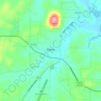
Name: Salem topographic map, elevation, terrain.

Location: Salem, Fulton County, Arkansas, United States (36.35309 -91.84535 36.38832 -91.80035)

Average elevation: 735 ft

Minimum elevation: 614 ft

Maximum elevation: 1,070 ft

Fulton County trails, hiking, mountain biking, running and outdoor activities

Other topographic maps

Click on a map to view its topography, its elevation and its terrain.

Elizabeth

United States > Arkansas > Fulton County

Average elevation: 764 ft

Gear up for your next adventure:

🎒Trekking Poles - Sturdy poles for balance and stability on rough terrain
🧣Hiking Neck Gaiter - Multi‑use neck protection for outdoor weather
🎒Trail Energy Bars - High‑calorie bars for hiking energy
🌧️Backpack Rain Cover - Keep gear dry in wet weather
Backpacking Tent - Lightweight and durable tent for multi‑day hikes

As an Amazon Associate, this site earns from qualifying purchases at no extra cost to you.