Geolocate

Baldwin topographic map

Click on the map to display elevation.

About this map

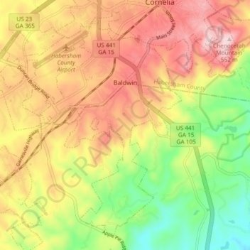
Name: Baldwin topographic map, elevation, terrain.

Location: Baldwin, Habersham County, Georgia, United States (34.45432 -83.59457 34.50830 -83.52045)

Average elevation: 1,296 ft

Minimum elevation: 771 ft

Maximum elevation: 1,785 ft

Habersham County trails, hiking, mountain biking, running and outdoor activities

Other topographic maps

Click on a map to view its topography, its elevation and its terrain.

Batesville

United States > Georgia > Habersham County

Average elevation: 1,752 ft

Turnerville

United States > Georgia > Habersham County

Average elevation: 1,519 ft

Tugaloo

United States > Georgia > Habersham County > Tallulah Falls

Average elevation: 1,286 ft

Habersham

United States > Georgia > Habersham County

Average elevation: 1,342 ft

Apple Pie Mountain

United States > Georgia > Habersham County

Average elevation: 1,762 ft

Gear up for your next adventure:

🛰️Handheld GPS Units - Professional satellite navigators for precise backcountry mapping
🪶Fire Starter Kit - Reliable fire starter for survival and camping
🧥Men's Rain Shells - Premium waterproof and breathable jackets for mountain weather
🏕️Tent Footprint - Protect your tent base from wear
🪶Wildlife Field Guides - Learn animal tracking and species ID

As an Amazon Associate, this site earns from qualifying purchases at no extra cost to you.