
Make a donation
Gear up for your next adventure:
As an Amazon Associate, this site earns from qualifying purchases at no extra cost to you.
Oley Township topographic map
Click on the map to display elevation.
Make a donation
Gear up for your next adventure:
As an Amazon Associate, this site earns from qualifying purchases at no extra cost to you.
About this map
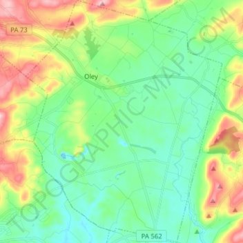
Name: Oley Township topographic map, elevation, terrain.
Location: Oley Township, Berks County, Pennsylvania, United States (40.32119 -75.82368 40.41785 -75.72111)
Average elevation: 459 ft
Minimum elevation: 220 ft
Maximum elevation: 1,004 ft
Berks County trails, hiking, mountain biking, running and outdoor activities
Make a donation
Gear up for your next adventure:
As an Amazon Associate, this site earns from qualifying purchases at no extra cost to you.
Other topographic maps
Click on a map to view its topography, its elevation and its terrain.
Riverview Park
United States > Pennsylvania > Berks County > Muhlenberg Township
Average elevation: 312 ft
State Hill
United States > Pennsylvania > Berks County > Lower Heidelberg Township
Average elevation: 348 ft
Make a donation
Gear up for your next adventure:
As an Amazon Associate, this site earns from qualifying purchases at no extra cost to you.
Trexler
United States > Pennsylvania > Berks County > Albany Township > Kempton
Average elevation: 538 ft
Make a donation
Gear up for your next adventure:
As an Amazon Associate, this site earns from qualifying purchases at no extra cost to you.
Windsor Castle
United States > Pennsylvania > Berks County > Windsor Township
Average elevation: 512 ft
Wintersville
United States > Pennsylvania > Berks County > Tulpehocken Township
Average elevation: 564 ft
Make a donation
Gear up for your next adventure:
As an Amazon Associate, this site earns from qualifying purchases at no extra cost to you.
Seisholtzville
United States > Pennsylvania > Berks County > Hereford Township
Average elevation: 853 ft
Make a donation
Gear up for your next adventure:
As an Amazon Associate, this site earns from qualifying purchases at no extra cost to you.
Pleasantville Park
United States > Pennsylvania > Berks County > Oley Township > Manatawny
Average elevation: 397 ft
Pricetown
United States > Pennsylvania > Berks County > Ruscombmanor Township
Average elevation: 784 ft
Make a donation
Gear up for your next adventure:
As an Amazon Associate, this site earns from qualifying purchases at no extra cost to you.
Muhlenberg Park
United States > Pennsylvania > Berks County > Muhlenberg Township
Average elevation: 308 ft
Make a donation
Gear up for your next adventure:
As an Amazon Associate, this site earns from qualifying purchases at no extra cost to you.
North Heidelberg
United States > Pennsylvania > Berks County > North Heidelberg Township
Average elevation: 436 ft
Moselem Springs
United States > Pennsylvania > Berks County > Richmond Township
Average elevation: 407 ft
Morysville
United States > Pennsylvania > Berks County > Colebrookdale Township
Average elevation: 440 ft
Make a donation
Gear up for your next adventure:
As an Amazon Associate, this site earns from qualifying purchases at no extra cost to you.
Maple Grove
United States > Pennsylvania > Berks County > Longswamp Township
Average elevation: 646 ft
Make a donation
Gear up for your next adventure:
As an Amazon Associate, this site earns from qualifying purchases at no extra cost to you.
Maiden Creek
United States > Pennsylvania > Berks County > Maidencreek Township > Blandon
Average elevation: 367 ft
Make a donation
Gear up for your next adventure:
As an Amazon Associate, this site earns from qualifying purchases at no extra cost to you.
Landis Store
United States > Pennsylvania > Berks County > District Township
Average elevation: 876 ft
Make a donation
Gear up for your next adventure:
As an Amazon Associate, this site earns from qualifying purchases at no extra cost to you.
Klinesville
United States > Pennsylvania > Berks County > Greenwich Township
Average elevation: 594 ft
Make a donation
Gear up for your next adventure:
As an Amazon Associate, this site earns from qualifying purchases at no extra cost to you.
Huffs Church
United States > Pennsylvania > Berks County > Hereford Township
Average elevation: 856 ft
Hinterleiter
United States > Pennsylvania > Berks County > Maxatawny Township
Average elevation: 463 ft
Make a donation
Gear up for your next adventure:
As an Amazon Associate, this site earns from qualifying purchases at no extra cost to you.
Henningsville
United States > Pennsylvania > Berks County > Longswamp Township
Average elevation: 965 ft
Green Hills Lake Dam
United States > Pennsylvania > Berks County > Robeson Township
Average elevation: 413 ft
Make a donation
Gear up for your next adventure:
As an Amazon Associate, this site earns from qualifying purchases at no extra cost to you.
Fredericksville
United States > Pennsylvania > Berks County > District Township
Average elevation: 978 ft
Make a donation
Gear up for your next adventure:
As an Amazon Associate, this site earns from qualifying purchases at no extra cost to you.
Evansville
United States > Pennsylvania > Berks County > Maidencreek Township
Average elevation: 371 ft
Eagle Point
United States > Pennsylvania > Berks County > Maxatawny Township
Average elevation: 548 ft
Make a donation
Gear up for your next adventure:
As an Amazon Associate, this site earns from qualifying purchases at no extra cost to you.
Make a donation
Gear up for your next adventure:
As an Amazon Associate, this site earns from qualifying purchases at no extra cost to you.
Cacoosing
United States > Pennsylvania > Berks County > Lower Heidelberg Township
Average elevation: 335 ft
Brownsville
United States > Pennsylvania > Berks County > Lower Heidelberg Township
Average elevation: 413 ft
Breezy Corner
United States > Pennsylvania > Berks County > Ruscombmanor Township
Average elevation: 827 ft
Make a donation
Gear up for your next adventure:
As an Amazon Associate, this site earns from qualifying purchases at no extra cost to you.
Boyers Junction
United States > Pennsylvania > Berks County > Rockland Township
Average elevation: 794 ft
Make a donation
Gear up for your next adventure:
As an Amazon Associate, this site earns from qualifying purchases at no extra cost to you.
Rehrersburg
United States > Pennsylvania > Berks County > Tulpehocken Township
Average elevation: 541 ft
Make a donation
Gear up for your next adventure:
As an Amazon Associate, this site earns from qualifying purchases at no extra cost to you.
Shartlesville
United States > Pennsylvania > Berks County > Upper Bern Township
Average elevation: 600 ft
Stony Creek Mills
United States > Pennsylvania > Berks County > Lower Alsace Township > Pennside
Average elevation: 630 ft
Make a donation
Gear up for your next adventure:
As an Amazon Associate, this site earns from qualifying purchases at no extra cost to you.
Pennside
United States > Pennsylvania > Berks County > Lower Alsace Township
Average elevation: 600 ft
Make a donation
Gear up for your next adventure:
As an Amazon Associate, this site earns from qualifying purchases at no extra cost to you.
New Shaefferstown
United States > Pennsylvania > Berks County > Jefferson Township
Average elevation: 469 ft
New Jerusalem
United States > Pennsylvania > Berks County > Rockland Township
Average elevation: 827 ft
New Berlinville
United States > Pennsylvania > Berks County > Colebrookdale Township
Average elevation: 430 ft
Montrose Manor Playground
United States > Pennsylvania > Berks County > Cumru Township > Montrose
Average elevation: 427 ft
Make a donation
Gear up for your next adventure:
As an Amazon Associate, this site earns from qualifying purchases at no extra cost to you.
Jacksonwald
United States > Pennsylvania > Berks County > Exeter Township > Village of Jacksonwald
Average elevation: 420 ft
Hyde Park
United States > Pennsylvania > Berks County > Muhlenberg Township > Muhlenberg Park
Average elevation: 351 ft
Make a donation
Gear up for your next adventure:
As an Amazon Associate, this site earns from qualifying purchases at no extra cost to you.
Make a donation
Gear up for your next adventure:
As an Amazon Associate, this site earns from qualifying purchases at no extra cost to you.
Make a donation
Gear up for your next adventure:
As an Amazon Associate, this site earns from qualifying purchases at no extra cost to you.