
Job Lake topographic map
Click on the map to display elevation.
About this map
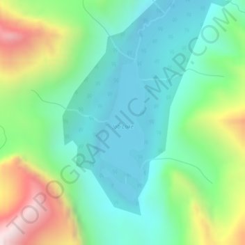
Name: Job Lake topographic map, elevation, terrain.
Location: Job Lake, Clearwater County, Alberta, Canada (52.36155 -116.85634 52.37496 -116.84827)
Average elevation: 7,592 ft
Minimum elevation: 6,680 ft
Maximum elevation: 9,747 ft
Other topographic maps
Click on a map to view its topography, its elevation and its terrain.
Nordegg
Canada > Alberta > Clearwater County
Nordegg has a subarctic climate (Dfc) which can be considered a subalpine climate due to its altitude with locations on the same latitude having warmer climates. Summers are mild, with a few warm days sprinkled in here and there, while winters are cold and snowy.
Average elevation: 4,839 ft
Nordegg
Canada > Alberta > Clearwater County
Nordegg has a subarctic climate (Dfc) which can be considered a subalpine climate due to its altitude with locations on the same latitude having warmer climates. Summers are mild, with a few warm days sprinkled in here and there, while winters are cold and snowy.
Average elevation: 4,590 ft