
Harrison Lake topographic map
Click on the map to display elevation.
About this map
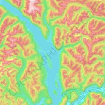
Name: Harrison Lake topographic map, elevation, terrain.
Average elevation: 2,674 ft
Minimum elevation: 10 ft
Maximum elevation: 7,887 ft
Other topographic maps
Click on a map to view its topography, its elevation and its terrain.
Chehalis Lake
Canada > British Columbia > Fraser Valley Regional District > Area C (Sasquatch Country)
Average elevation: 2,411 ft
Sloquet Creek
Canada > British Columbia > Fraser Valley Regional District > Area C (Sasquatch Country)
Average elevation: 837 ft
Harrison Mills
Canada > British Columbia > Fraser Valley Regional District > Area C (Sasquatch Country)
Average elevation: 312 ft
Hemlock Valley
Canada > British Columbia > Fraser Valley Regional District > Area C (Sasquatch Country)
Average elevation: 3,629 ft
Mount Fletcher
Canada > British Columbia > Fraser Valley Regional District > Area C (Sasquatch Country)
Average elevation: 3,127 ft
Chehalis River
Canada > British Columbia > Fraser Valley Regional District > Area C (Sasquatch Country)
Average elevation: 1,391 ft
Turner Glacier
Canada > British Columbia > Fraser Valley Regional District > Area C (Sasquatch Country)
Average elevation: 7,162 ft
Mount Fletcher
Canada > British Columbia > Fraser Valley Regional District > Area C (Sasquatch Country)
Average elevation: 3,127 ft