
Brusand topographic map
Interactive map
Click on the map to display elevation.
About this map
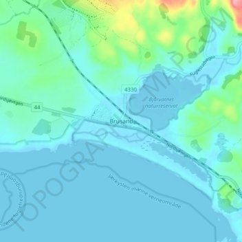
Name: Brusand topographic map, elevation, terrain.
Location: Brusand, Hå, Rogaland, 4363, Norvège (58.52054 5.72485 58.56054 5.76485)
Average elevation: 49 ft
Minimum elevation: -13 ft
Maximum elevation: 371 ft
Other topographic maps
Click on a map to view its topography, its elevation and its terrain.
Vassfjellet
Vassfjellet, Sandbakk, Sandnes, Rogaland, 4309, Norvège
Average elevation: 407 ft