
Randaberg topographic map
Interactive map
Click on the map to display elevation.
About this map
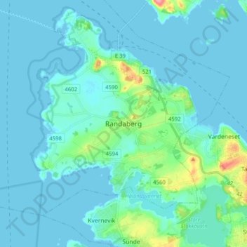
Name: Randaberg topographic map, elevation, terrain.
Location: Randaberg, Rogaland, 4070, Norvège (58.95945 5.57657 59.03945 5.65657)
Average elevation: 33 ft
Minimum elevation: -3 ft
Maximum elevation: 282 ft
Other topographic maps
Click on a map to view its topography, its elevation and its terrain.
Vassfjellet
Vassfjellet, Sandbakk, Sandnes, Rogaland, 4309, Norvège
Average elevation: 407 ft