Geolocate

Canton topographic map

Click on the map to display elevation.

About this map

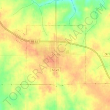
Name: Canton topographic map, elevation, terrain.

Location: Canton, Fillmore County, Minnesota, United States (43.52237 -91.94358 43.53692 -91.91962)

Average elevation: 1,322 ft

Minimum elevation: 1,230 ft

Maximum elevation: 1,365 ft

Fillmore County trails, hiking, mountain biking, running and outdoor activities

Other topographic maps

Click on a map to view its topography, its elevation and its terrain.

Chatfield

United States > Minnesota > Fillmore County

Average elevation: 1,073 ft

Highland

United States > Minnesota > Fillmore County

Average elevation: 1,152 ft

Gear up for your next adventure:

🚪Portable Camp Chair - Foldable chair for comfort at camp
🔌USB Car Charger - Car charger for on‑the‑go power needs
🛡️Insect Repellent - Protection against bugs during outdoor activities
🦶Carbon Trekking Poles - Reduce knee impact on steep descents with ultra-light poles
🔦Powerful Headlamps - Ultra-bright hands-free lighting for night navigation

As an Amazon Associate, this site earns from qualifying purchases at no extra cost to you.