
Putumayo topographic map
Interactive map
Click on the map to display elevation.
About this map
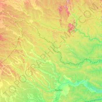
Name: Putumayo topographic map, elevation, terrain.
Location: Putumayo, Loreto, Peru (-3.42422 -75.61055 -0.03928 -70.05883)
Average elevation: 535 ft
Minimum elevation: 223 ft
Maximum elevation: 2,054 ft
Other topographic maps
Click on a map to view its topography, its elevation and its terrain.
Francisco de Orellana
Peru > Loreto > Las Amazonas
Francisco de Orellana, Las Amazonas, Province of Maynas, Loreto, Peru
Average elevation: 266 ft
Naciente del Amazonas
Naciente del Amazonas, Nauta, Province of Loreto, Loreto, 16301, Peru
Average elevation: 325 ft
Santa Fe
Peru > Loreto > Emilio San Martín
Santa Fe, Emilio San Martín, Province of Requena, Loreto, Peru
Average elevation: 338 ft
Cuchara
Peru > Loreto > Trompeteros
Cuchara, Trompeteros, Province of Loreto, Loreto, Peru
Average elevation: 413 ft
San Sebastian
San Sebastian, Yavari, Province of Mariscal Ramón Castilla, Loreto, Peru
Average elevation: 272 ft
Mariscal Castilla
Mariscal Castilla, Nauta, Province of Loreto, Loreto, Peru
Average elevation: 292 ft
Cartagena
Peru > Loreto > Yurimaguas > Cartagena
Cartagena, Yurimaguas, Province of Alto Amazonas, Loreto, Peru
Average elevation: 476 ft
Quebrada SanJuan
Peru > Loreto > Trompeteros
Quebrada SanJuan, Trompeteros, Province of Loreto, Loreto, Peru
Average elevation: 479 ft
Province of Alto Amazonas
Province of Alto Amazonas, Loreto, Peru
Average elevation: 738 ft
Province of Datem del Marañón
Province of Datem del Marañón, Loreto, Peru
Average elevation: 1,266 ft
Province of Alto Amazonas
Province of Alto Amazonas, Jeberos, Alto Amazonas, Loreto, Peru
Average elevation: 417 ft
Province of Datem del Marañón
Province of Datem del Marañón, Pastaza, Datem del Marañón, Loreto, Peru
Average elevation: 564 ft
Atlantida
Peru > Loreto > Manseriche
Atlantida, Manseriche, Province of Datem del Marañón, Loreto, Peru
Average elevation: 463 ft
Chanchamayo
Peru > Loreto > Chanchamayo
Chanchamayo, Province of Loreto, Loreto, Peru
Average elevation: 358 ft