Geolocate

Mullan topographic map

Click on the map to display elevation.

Mullan

In Shoshone County at the east end of the Silver Valley, Mullan is in a sheltered canyon of the Coeur d'Alene Mountains at an elevation of 3,278 feet (1,000 m) above sea level. The entrance to the Lucky Friday mine is several hundred yards east of the city center; the active mine (silver, lead, & zinc) descends more than six thousand feet (1.1 mi; 1.8 km) below the surface.

Wikipedia (CC-BY-SA 3.0)

About this map

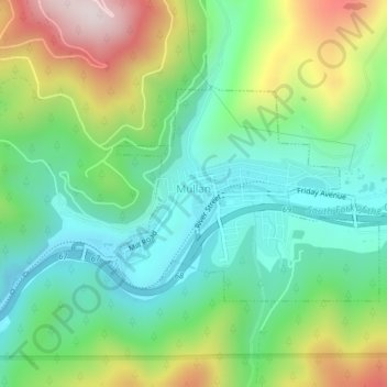
Name: Mullan topographic map, elevation, terrain.

Location: Mullan, Shoshone County, Idaho, 83846, United States (47.46237 -115.81073 47.47740 -115.78263)

Average elevation: 3,832 ft

Minimum elevation: 3,156 ft

Maximum elevation: 5,174 ft

Shoshone County trails, hiking, mountain biking, running and outdoor activities

Other topographic maps

Click on a map to view its topography, its elevation and its terrain.

Kingston

United States > Idaho > Shoshone County

Average elevation: 2,395 ft

Burke

United States > Idaho > Shoshone County > Mace

Burke is located about 7 miles (11 km) northeast of Wallace, at an elevation of 3,700 feet (1,130 m) above sea level. It is accessed from Wallace on Burke-Canyon Creek Road (State Highway 4). The town is located approximately 100 miles (160 km) south of the Canadian province of British Columbia, and roughly 5…

Average elevation: 4,787 ft

Page

United States > Idaho > Shoshone County

Average elevation: 2,697 ft

Pocono

United States > Idaho > Shoshone County

Average elevation: 2,936 ft

Clarkia

United States > Idaho > Shoshone County

Average elevation: 3,048 ft

Moon Peak

United States > Idaho > Shoshone County

Average elevation: 4,767 ft

South Butte

United States > Idaho > Shoshone County

Average elevation: 6,106 ft

Turkey Point

United States > Idaho > Shoshone County

Average elevation: 5,262 ft

McDonalds

United States > Idaho > Shoshone County

Average elevation: 5,551 ft

tiger peak

United States > Idaho > Shoshone County

Average elevation: 5,614 ft

Horsecamp

United States > Idaho > Shoshone County

Average elevation: 3,973 ft

Spion Kop

United States > Idaho > Shoshone County

Average elevation: 4,711 ft

Kingston

United States > Idaho > Shoshone County

Average elevation: 2,395 ft

Gear up for your next adventure:

🎒Trail Energy Bars - High‑calorie bars for hiking energy
🚗GPS Dash Cams - Record your scenic drives through mountain passes and canyons
📷Action Cameras - Rugged cameras to document your journeys across rugged terrain
☀️Outdoor Sunscreen - High protection sunscreen for outdoor activities
🌧️Backpack Rain Cover - Keep gear dry in wet weather

As an Amazon Associate, this site earns from qualifying purchases at no extra cost to you.