
Make a donation
Gear up for your next adventure:
As an Amazon Associate, this site earns from qualifying purchases at no extra cost to you.
Mazowe topographic map
Click on the map to display elevation.
Make a donation
Gear up for your next adventure:
As an Amazon Associate, this site earns from qualifying purchases at no extra cost to you.
About this map
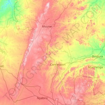
Name: Mazowe topographic map, elevation, terrain.
Location: Mazowe, Mashonaland Central Province, Zimbabwe (-17.74197 30.61122 -16.78811 31.28514)
Average elevation: 4,226 ft
Minimum elevation: 2,992 ft
Maximum elevation: 5,709 ft
Make a donation
Gear up for your next adventure:
As an Amazon Associate, this site earns from qualifying purchases at no extra cost to you.
Other topographic maps
Click on a map to view its topography, its elevation and its terrain.
Negomo Irrigation Dam
Zimbabwe > Mashonaland Central Province > Mhasvi Village
Average elevation: 4,206 ft
Make a donation
Gear up for your next adventure:
As an Amazon Associate, this site earns from qualifying purchases at no extra cost to you.