Blatten topographic map
Interactive map
Click on the map to display elevation.
About this map
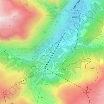
Name: Blatten topographic map, elevation, terrain.
Location: Blatten, Zermatt, Visp, Wallis, 3920, Switzerland (45.98762 7.71604 46.02762 7.75604)
Average elevation: 7,051 ft
Minimum elevation: 5,233 ft
Maximum elevation: 9,478 ft
Other topographic maps
Click on a map to view its topography, its elevation and its terrain.
Matterhorn
Switzerland > Wallis > Visp > Zermatt
Matterhorn, Zermatt, Visp, Wallis, 3920, Switzerland
Average elevation: 10,810 ft
Gobba di Rollin
Switzerland > Wallis > Visp > Zermatt
Gobba di Rollin, Zermatt, Visp, Wallis, 3920, Switzerland
Average elevation: 11,778 ft
Monte Rosa
Switzerland > Wallis > Visp > Zermatt
Monte Rosa, Zermatt, Visp, Wallis, 3920, Switzerland
Average elevation: 13,232 ft
Gornera
Switzerland > Wallis > Visp > Zermatt
Gornera, Zermatt, Visp, Wallis, 3920, Switzerland
Average elevation: 7,303 ft