Make a donation
Gear up for your next adventure:
As an Amazon Associate, this site earns from qualifying purchases at no extra cost to you.
Toledo topographic map
Click on the map to display elevation.
Gear up for your next adventure:
As an Amazon Associate, this site earns from qualifying purchases at no extra cost to you.
About this map
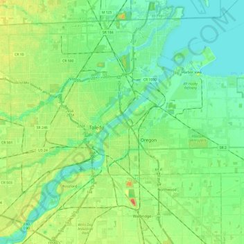
Name: Toledo topographic map, elevation, terrain.
Location: Toledo, Lucas County, Ohio, United States (41.58027 -83.69424 41.73285 -83.45461)
Average elevation: 614 ft
Minimum elevation: 558 ft
Maximum elevation: 705 ft
Lucas County trails, hiking, mountain biking, running and outdoor activities
Make a donation
Gear up for your next adventure:
As an Amazon Associate, this site earns from qualifying purchases at no extra cost to you.
Other topographic maps
Click on a map to view its topography, its elevation and its terrain.
Make a donation
Gear up for your next adventure:
As an Amazon Associate, this site earns from qualifying purchases at no extra cost to you.
Make a donation
Gear up for your next adventure:
As an Amazon Associate, this site earns from qualifying purchases at no extra cost to you.
Air Line Junction
United States > Ohio > Lucas County > Toledo > Air Line Junction
Average elevation: 623 ft
