
Make a donation
Gear up for your next adventure:
As an Amazon Associate, this site earns from qualifying purchases at no extra cost to you.
Inn topographic map
Click on the map to display elevation.
Make a donation
Gear up for your next adventure:
As an Amazon Associate, this site earns from qualifying purchases at no extra cost to you.
About this map
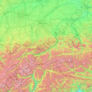
Name: Inn topographic map, elevation, terrain.
Location: Inn, 6500, Austria (46.40649 9.66645 48.57464 13.48480)
Average elevation: 3,780 ft
Minimum elevation: 518 ft
Maximum elevation: 12,631 ft
Make a donation
Gear up for your next adventure:
As an Amazon Associate, this site earns from qualifying purchases at no extra cost to you.
Other topographic maps
Click on a map to view its topography, its elevation and its terrain.
Hochfügen
Austria > Tyrol > Bezirk Schwaz > Gemeinde Fügenberg > Hochfügen
Average elevation: 6,050 ft
Make a donation
Gear up for your next adventure:
As an Amazon Associate, this site earns from qualifying purchases at no extra cost to you.
Königsleiten
Austria > Salzburg > Bezirk Zell am See > Gemeinde Wald im Pinzgau > Königsleiten
Average elevation: 5,587 ft