
Make a donation
Gear up for your next adventure:
As an Amazon Associate, this site earns from qualifying purchases at no extra cost to you.
Don Bosco topographic map
Click on the map to display elevation.
Make a donation
Gear up for your next adventure:
As an Amazon Associate, this site earns from qualifying purchases at no extra cost to you.
About this map
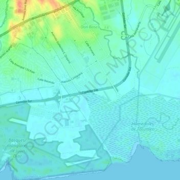
Name: Don Bosco topographic map, elevation, terrain.
Location: Don Bosco, Distrito Panamá, Panamá (9.01336 -79.44398 9.06503 -79.39797)
Average elevation: 26 ft
Minimum elevation: 0 ft
Maximum elevation: 141 ft
Make a donation
Gear up for your next adventure:
As an Amazon Associate, this site earns from qualifying purchases at no extra cost to you.
Other topographic maps
Click on a map to view its topography, its elevation and its terrain.
Make a donation
Gear up for your next adventure:
As an Amazon Associate, this site earns from qualifying purchases at no extra cost to you.
Bosque Urbano de Paraíso Centro
Panamá > Panamá > Distrito Panamá > Ancón > Paraíso
Average elevation: 226 ft
Make a donation
Gear up for your next adventure:
As an Amazon Associate, this site earns from qualifying purchases at no extra cost to you.