
Dakota County topographic map
Interactive map
Click on the map to display elevation.
About this map
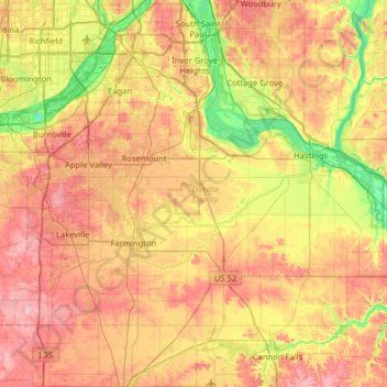
Name: Dakota County topographic map, elevation, terrain.
Location: Dakota County, Minnesota, United States (44.47118 -93.32983 44.92329 -92.73220)
Average elevation: 912 ft
Minimum elevation: 617 ft
Maximum elevation: 1,227 ft
Other topographic maps
Click on a map to view its topography, its elevation and its terrain.
Minneapolis
United States > Minnesota > Hennepin County
Minneapolis, Hennepin County, Minnesota, United States
Average elevation: 886 ft
Minneapolis
United States > Minnesota > Hennepin County > Minneapolis
Minneapolis, Hennepin County, Minnesota, 55488, United States
Average elevation: 889 ft
Saint Paul
United States > Minnesota > Ramsey County
Saint Paul, Ramsey County, Minnesota, United States
Average elevation: 879 ft
Duluth
United States > Minnesota > Saint Louis County
Duluth, Saint Louis County, Minnesota, United States
Average elevation: 938 ft
Balaton
United States > Minnesota > Lyon County
Balaton, Lyon County, Minnesota, United States
Average elevation: 1,545 ft
Maple Grove
United States > Minnesota > Hennepin County
Maple Grove, Hennepin County, Minnesota, United States
Average elevation: 912 ft
Mankato
United States > Minnesota > Blue Earth County
Mankato, Blue Earth County, Minnesota, 56001, United States
Average elevation: 935 ft
Eagan
United States > Minnesota > Dakota County
Eagan, Dakota County, Minnesota, United States
Average elevation: 876 ft
Rochester
United States > Minnesota > Olmsted County
Rochester, Olmsted County, Minnesota, United States
Average elevation: 1,161 ft
Olmsted County
Olmsted County, Minnesota, United States
Average elevation: 1,161 ft
Crow Wing County
Crow Wing County, Minnesota, United States
Average elevation: 1,266 ft
City park
United States > Minnesota > Saint Louis County > Duluth
City park, Lakeside-Lester Park, Duluth, Saint Louis County, Minnesota, United States
Average elevation: 676 ft
Bloomington
United States > Minnesota > Hennepin County
Bloomington, Hennepin County, Minnesota, United States
Average elevation: 837 ft
Itasca County
Itasca County, Minnesota, United States
Average elevation: 1,352 ft
Country Valley Mobile Home Park
United States > Minnesota > Winona County > Goodview
Country Valley Mobile Home Park, Goodview, Winona County, Minnesota, 55959, United States
Average elevation: 758 ft
Le Sueur County
Le Sueur County, Minnesota, United States
Average elevation: 1,017 ft
Battle Creek
United States > Minnesota > Ramsey County > Saint Paul
Battle Creek, Southeast, Saint Paul, Ramsey County, Minnesota, United States
Average elevation: 866 ft
Washington County
Washington County, Minnesota, United States
Average elevation: 928 ft
Barrett
United States > Minnesota > Grant County
Barrett, Grant County, Minnesota, 56311, United States
Average elevation: 1,191 ft
Big Moose Lake
United States > Minnesota > Saint Louis County
Big Moose Lake, Northeast St Louis, Saint Louis County, Minnesota, United States
Average elevation: 1,417 ft
Bucks Mill
United States > Minnesota > Becker County
Bucks Mill, Becker County, Minnesota, United States
Average elevation: 1,345 ft
Bemidji
United States > Minnesota > Beltrami County
Bemidji, Beltrami County, Minnesota, 56601, United States
Average elevation: 1,368 ft
Stillwater
United States > Minnesota > Washington County
Stillwater, Washington County, Minnesota, United States
Average elevation: 850 ft
Bonnevista Terrace Mobile Home Park
United States > Minnesota > Scott County
Bonnevista Terrace Mobile Home Park, Jackson Township, Scott County, Minnesota, United States
Average elevation: 791 ft
Kittson County
Kittson County, Minnesota, United States
Average elevation: 902 ft
Cook County
Cook County, Minnesota, United States
Average elevation: 1,260 ft
Hills
United States > Minnesota > Rock County
Hills, Martin Township, Rock County, Minnesota, 56138, United States
Average elevation: 1,460 ft
Green Lake
United States > Minnesota > Beltrami County > Little Rock
Green Lake, Little Rock, Beltrami County, Minnesota, United States
Average elevation: 1,243 ft
West St. Paul
United States > Minnesota > Dakota County
West St. Paul, Dakota County, Minnesota, 55118, United States
Average elevation: 965 ft
Grey Cloud Island
United States > Minnesota > Washington County > Grey Cloud Island Township
Grey Cloud Island, Grey Cloud Island Township, Washington County, Minnesota, 55071, United States
Average elevation: 738 ft
Minnetonka
United States > Minnesota > Hennepin County
Minnetonka, Hennepin County, Minnesota, United States
Average elevation: 951 ft
Sherburne County
Sherburne County, Minnesota, United States
Average elevation: 978 ft
Dunnell
United States > Minnesota > Martin County
Dunnell, Martin County, Minnesota, United States
Average elevation: 1,322 ft
Gainy Park
United States > Minnesota > Steele County > Owatonna
Gainy Park, Owatonna, Steele County, Minnesota, United States
Average elevation: 1,178 ft
Glendale
United States > Minnesota > Scott County > Savage
Glendale, Savage, Scott County, Minnesota, 55378, United States
Average elevation: 860 ft
Big Deep Lake
United States > Minnesota > Cass County
Big Deep Lake, Cass County, Minnesota, United States
Average elevation: 1,378 ft
Shorewood
United States > Minnesota > Hennepin County
Shorewood, Tonka Bay, Hennepin County, Minnesota, 55331, United States
Average elevation: 961 ft
Stanchfield
United States > Minnesota > Isanti County
Stanchfield, Stanchfield Township, Isanti County, Minnesota, 55080, United States
Average elevation: 942 ft
Bodum
United States > Minnesota > Isanti County
Bodum, Isanti Township, Isanti County, Minnesota, 55008, United States
Average elevation: 965 ft
Wyanett
United States > Minnesota > Isanti County
Wyanett, Wyanett Township, Isanti County, Minnesota, United States
Average elevation: 961 ft
Stanchfield Corner
United States > Minnesota > Isanti County
Stanchfield Corner, Stanchfield Township, Isanti County, Minnesota, 55080, United States
Average elevation: 942 ft
Spring Lake
United States > Minnesota > Isanti County
Spring Lake, North Branch Township, Isanti County, Minnesota, United States
Average elevation: 938 ft
Oxlip
United States > Minnesota > Isanti County
Oxlip, Bradford Township, Isanti County, Minnesota, United States
Average elevation: 945 ft
Elm Park
United States > Minnesota > Isanti County
Elm Park, Maple Ridge Township, Isanti County, Minnesota, United States
Average elevation: 951 ft
Crown
United States > Minnesota > Isanti County
Crown, Stanford Township, Isanti County, Minnesota, United States
Average elevation: 968 ft
Weber
United States > Minnesota > Isanti County
Weber, North Branch Township, Isanti County, Minnesota, United States
Average elevation: 925 ft
Walbo
United States > Minnesota > Isanti County
Walbo, Springvale Township, Isanti County, Minnesota, United States
Average elevation: 938 ft
Springvale
United States > Minnesota > Isanti County
Springvale, Springvale Township, Isanti County, Minnesota, United States
Average elevation: 945 ft
Pine Brook
United States > Minnesota > Isanti County
Pine Brook, Springvale Township, Isanti County, Minnesota, United States
Average elevation: 955 ft
Grandy
United States > Minnesota > Isanti County
Grandy, Cambridge Township, Isanti County, Minnesota, 55029, United States
Average elevation: 935 ft