
Make a donation
Gear up for your next adventure:
As an Amazon Associate, this site earns from qualifying purchases at no extra cost to you.
Herrlesberg/Stäudach topographic map
Click on the map to display elevation.
Make a donation
Gear up for your next adventure:
As an Amazon Associate, this site earns from qualifying purchases at no extra cost to you.
About this map
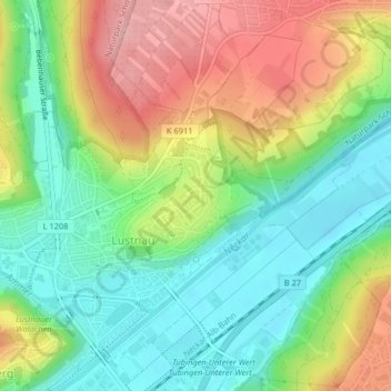
Name: Herrlesberg/Stäudach topographic map, elevation, terrain.
Average elevation: 1,217 ft
Minimum elevation: 1,004 ft
Maximum elevation: 1,526 ft
Make a donation
Gear up for your next adventure:
As an Amazon Associate, this site earns from qualifying purchases at no extra cost to you.
Other topographic maps
Click on a map to view its topography, its elevation and its terrain.
Pfrondorf
Deutschland > Baden-Württemberg > Landkreis Tübingen > Tübingen > Pfrondorf
Average elevation: 1,345 ft
Steinenberg
Deutschland > Baden-Württemberg > Landkreis Tübingen > Tübingen
Average elevation: 1,325 ft
Lichtenberger Höhe
Deutschland > Baden-Württemberg > Landkreis Tübingen > Tübingen
Average elevation: 1,158 ft
Sengental
Deutschland > Baden-Württemberg > Landkreis Tübingen > Tübingen > Bühl
Average elevation: 1,352 ft
Make a donation
Gear up for your next adventure:
As an Amazon Associate, this site earns from qualifying purchases at no extra cost to you.
Waldhausen
Deutschland > Baden-Württemberg > Landkreis Tübingen > Tübingen
Average elevation: 1,430 ft
Sengental
Deutschland > Baden-Württemberg > Landkreis Tübingen > Tübingen > Bühl
Average elevation: 1,352 ft