
Make a donation
Gear up for your next adventure:
As an Amazon Associate, this site earns from qualifying purchases at no extra cost to you.
Steinenberg topographic map
Click on the map to display elevation.
Make a donation
Gear up for your next adventure:
As an Amazon Associate, this site earns from qualifying purchases at no extra cost to you.
About this map
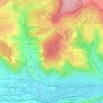
Name: Steinenberg topographic map, elevation, terrain.
Average elevation: 1,325 ft
Minimum elevation: 1,079 ft
Maximum elevation: 1,660 ft
Make a donation
Gear up for your next adventure:
As an Amazon Associate, this site earns from qualifying purchases at no extra cost to you.
Other topographic maps
Click on a map to view its topography, its elevation and its terrain.
Waldhäuser Ost
Deutschland > Baden-Württemberg > Landkreis Tübingen > Tübingen
Waldhäuser Ost ist der höchstgelegene Stadtteil am nördlichen Stadtrand und liegt auf einer leicht geneigten Anhöhe. Die westliche Abgrenzung zum Stadtteil Wanne ist die Waldhäuser Straße und die südliche zum Stadtteil Schönblick/Winkelwiese ist der Nordring. Das Studentendorf WHO wird durch den…
Average elevation: 1,388 ft
Make a donation
Gear up for your next adventure:
As an Amazon Associate, this site earns from qualifying purchases at no extra cost to you.
Sengental
Deutschland > Baden-Württemberg > Landkreis Tübingen > Tübingen > Bühl
Average elevation: 1,352 ft
Herrlesberg/Stäudach
Deutschland > Baden-Württemberg > Landkreis Tübingen > Tübingen
Average elevation: 1,217 ft
Waldhausen
Deutschland > Baden-Württemberg > Landkreis Tübingen > Tübingen
Average elevation: 1,430 ft
Sengental
Deutschland > Baden-Württemberg > Landkreis Tübingen > Tübingen > Bühl
Average elevation: 1,352 ft
Make a donation
Gear up for your next adventure:
As an Amazon Associate, this site earns from qualifying purchases at no extra cost to you.