
Make a donation
Gear up for your next adventure:
As an Amazon Associate, this site earns from qualifying purchases at no extra cost to you.
Ath Mansour topographic map
Click on the map to display elevation.
Make a donation
Gear up for your next adventure:
As an Amazon Associate, this site earns from qualifying purchases at no extra cost to you.
About this map
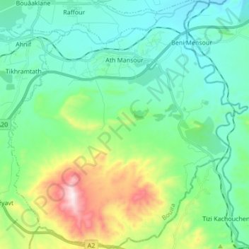
Name: Ath Mansour topographic map, elevation, terrain.
Location: Ath Mansour, Daïra M'Chedallah, Bouira, Algérie (36.24433 4.25510 36.35427 4.38481)
Average elevation: 1,453 ft
Minimum elevation: 840 ft
Maximum elevation: 3,399 ft
Make a donation
Gear up for your next adventure:
As an Amazon Associate, this site earns from qualifying purchases at no extra cost to you.
Other topographic maps
Click on a map to view its topography, its elevation and its terrain.
Lalla Khedidja
Algérie > Bouira > Daïra M'Chedallah > Saharidj
Lalla Khedidja (en kabyle : Lalla Xliǧa ou Tamgut) est le point culminant de l'Atlas tellien, en Afrique du Nord-Ouest, et plus précisément du massif du Djurdjura en Kabylie, en Algérie. Son altitude est de 2 308 mètres.
Average elevation: 5,764 ft