
Wagner Butte topographic map
Click on the map to display elevation.
About this map
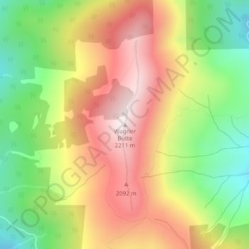
Name: Wagner Butte topographic map, elevation, terrain.
Location: Wagner Butte, Jackson County, Oregon, United States (42.11840 -122.77427 42.11850 -122.77417)
Average elevation: 6,063 ft
Minimum elevation: 4,921 ft
Maximum elevation: 7,201 ft
Jackson County trails, hiking, mountain biking, running and outdoor activities
Other topographic maps
Click on a map to view its topography, its elevation and its terrain.
Central Point
United States > Oregon > Jackson County
The city lies at an elevation of about 1,272 feet (388 m) along Oregon Highway 99 and Interstate 5 northwest of Medford. Jacksonville is to the south and Gold Hill to the northwest. The Central Oregon and Pacific Railroad passes through Central Point.
Average elevation: 1,263 ft
Lost Creek Lake
United States > Oregon > Jackson County
The primary purpose of the dam is flood control and is operated in conjunction with Applegate Dam to regulate water flows down the river as well as to impound water for summer use. The dam is an earthfill structure with a gated spillway and contains two hydroelectric generating units with a total capacity of…
Average elevation: 2,392 ft