
Fish Lake topographic map
Click on the map to display elevation.
About this map
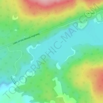
Name: Fish Lake topographic map, elevation, terrain.
Location: Fish Lake, Jackson County, Oregon, United States (42.37760 -122.34859 42.39413 -122.31340)
Average elevation: 4,777 ft
Minimum elevation: 4,590 ft
Maximum elevation: 5,144 ft
Jackson County trails, hiking, mountain biking, running and outdoor activities
Other topographic maps
Click on a map to view its topography, its elevation and its terrain.
Central Point
United States > Oregon > Jackson County
The city lies at an elevation of about 1,272 feet (388 m) along Oregon Highway 99 and Interstate 5 northwest of Medford. Jacksonville is to the south and Gold Hill to the northwest. The Central Oregon and Pacific Railroad passes through Central Point.
Average elevation: 1,263 ft
Siskiyou Gap
United States > Oregon > Jackson County
"The original pass crosses the divide between the Rogue and Klamath Rivers at a slight topographic notch formed by the geological contact between the older Siskiyou Mountains to the west and the younger volcanic Cascade Range to the east." (Jeffrey M. LaLande, retired, forest archaeologist, Rogue…
Average elevation: 5,728 ft