
Town of Shediac topographic map
Click on the map to display elevation.
Town of Shediac
Its topography is relatively flat and its soil is mostly composed of sedimentary rocks dating from the Pennsylvanian. Shediac enjoys a continental climate.
About this map
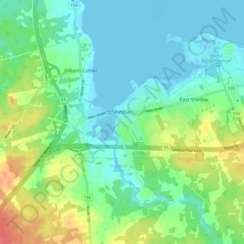
Name: Town of Shediac topographic map, elevation, terrain.
Location: Town of Shediac, Westmorland County, New Brunswick, Canada (46.08435 -64.66668 46.28112 -64.46296)
Average elevation: 92 ft
Minimum elevation: -10 ft
Maximum elevation: 249 ft
Other topographic maps
Click on a map to view its topography, its elevation and its terrain.
Memramcook Lake
Canada > New Brunswick > Westmorland County > Dorchester Parish
Average elevation: 62 ft
Haute-Aboujagane
Canada > New Brunswick > Westmorland County > Beaubassin East
Average elevation: 92 ft
Johnson's Mills
Canada > New Brunswick > Westmorland County > Johnson's Mills
Average elevation: 79 ft