Geolocate

Kumpur topographic map

Click on the map to display elevation.

About this map

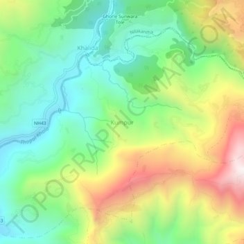
Name: Kumpur topographic map, elevation, terrain.

Location: Kumpur, Siddhalek, Dhading, Bagmati Province, 45100, Nepal (27.83285 84.85153 27.87285 84.89153)

Average elevation: 2,753 ft

Minimum elevation: 1,404 ft

Maximum elevation: 5,033 ft

Other topographic maps

Click on a map to view its topography, its elevation and its terrain.

Jwalamukhi

Nepal > Bagmati Province > Dhading

Average elevation: 2,595 ft

Netrawati

Nepal > Bagmati Province > Dhading

Average elevation: 3,842 ft

Gear up for your next adventure:

🧯Emergency Survival Kit - All‑in‑one survival essentials for the backcountry
🚪Portable Camp Chair - Foldable chair for comfort at camp
🪶Wildlife Field Guides - Learn animal tracking and species ID
🕶️GPS Smartphone Mount - Secure mount for phone navigation
🧣Merino Neck Gaiters - Multi-functional headwear for wind and sun protection

As an Amazon Associate, this site earns from qualifying purchases at no extra cost to you.