Geolocate

Bilton topographic map

Click on the map to display elevation.

About this map

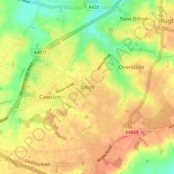
Name: Bilton topographic map, elevation, terrain.

Location: Bilton, Rugby, Warwickshire, England, CV22 7NL, United Kingdom (52.33735 -1.31283 52.37735 -1.27283)

Average elevation: 364 ft

Minimum elevation: 269 ft

Maximum elevation: 427 ft

Other topographic maps

Click on a map to view its topography, its elevation and its terrain.

Withybrook CP

United Kingdom > England > Warwickshire > Rugby

Average elevation: 377 ft

Draycote Water

United Kingdom > England > Warwickshire > Rugby > Draycote

Average elevation: 302 ft

Wolvey CP

United Kingdom > England > Warwickshire > Rugby

Average elevation: 371 ft

Churchover CP

United Kingdom > England > Warwickshire > Rugby

Average elevation: 377 ft

Binley Woods CP

United Kingdom > England > Warwickshire > Rugby

Average elevation: 282 ft

Pailton CP

United Kingdom > England > Warwickshire > Rugby

Average elevation: 384 ft

Ansty CP

United Kingdom > England > Warwickshire > Rugby

Average elevation: 299 ft

King's Newnham CP

United Kingdom > England > Warwickshire > Rugby

Average elevation: 285 ft

Birdingbury CP

United Kingdom > England > Warwickshire > Rugby

Average elevation: 269 ft

Long Lawford

United Kingdom > England > Warwickshire > Rugby

Average elevation: 331 ft

Grandborough CP

United Kingdom > England > Warwickshire > Rugby

Average elevation: 302 ft

Burton Hastings CP

United Kingdom > England > Warwickshire > Rugby

Average elevation: 335 ft

Cawston

United Kingdom > England > Warwickshire > Rugby

Average elevation: 358 ft

Dunchurch

United Kingdom > England > Warwickshire > Rugby

Average elevation: 335 ft

Frankton CP

United Kingdom > England > Warwickshire > Rugby > Frankton CP

Average elevation: 312 ft

Wibtoft CP

United Kingdom > England > Warwickshire > Rugby > Wibtoft CP

Average elevation: 407 ft

Church Lawford CP

United Kingdom > England > Warwickshire > Rugby

Average elevation: 322 ft

Thurlaston CP

United Kingdom > England > Warwickshire > Rugby

Average elevation: 322 ft

Monks Kirby CP

United Kingdom > England > Warwickshire > Rugby

Average elevation: 384 ft

Harborough Magna CP

United Kingdom > England > Warwickshire > Rugby

Average elevation: 348 ft

Brinklow CP

United Kingdom > England > Warwickshire > Rugby

Average elevation: 295 ft

Churchover CP

United Kingdom > England > Warwickshire > Rugby

Average elevation: 377 ft

Dunchurch

United Kingdom > England > Warwickshire > Rugby

Average elevation: 335 ft

Thurlaston CP

United Kingdom > England > Warwickshire > Rugby

Average elevation: 322 ft

Gear up for your next adventure:

🗺️NatGeo Topo Maps - High-quality waterproof printed topographic maps of US Parks
🩳Quick‑Dry Hiking Shorts - Comfortable and quick‑dry shorts for summer hiking
🩹Survival Bandages - High‑quality bandages for emergencies
🪶Fire Starter Kit - Reliable fire starter for survival and camping
🪶Paracord Bracelet - Survival bracelet with built‑in tools

As an Amazon Associate, this site earns from qualifying purchases at no extra cost to you.