Geolocate

Greenwood topographic map

Click on the map to display elevation.

About this map

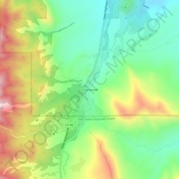
Name: Greenwood topographic map, elevation, terrain.

Location: Greenwood, Custer County, Colorado, 81253, United States (38.18573 -105.11654 38.22573 -105.07654)

Average elevation: 6,762 ft

Minimum elevation: 6,148 ft

Maximum elevation: 7,717 ft

Custer County trails, hiking, mountain biking, running and outdoor activities

Other topographic maps

Click on a map to view its topography, its elevation and its terrain.

Westcliffe

United States > Colorado > Custer County

Average elevation: 7,887 ft

Silver Cliff

United States > Colorado > Custer County

Average elevation: 8,054 ft

Gear up for your next adventure:

🧢Outdoor Hiking Hat - Sun protection hat for outdoor explorers
🪶LED Camping Lantern - Bright lantern for camp lighting
🛰️Satellite Messengers - Emergency SOS and two-way messaging for off-grid adventures
🧯Portable Fire Pit - Compact fire pit for camping spots
👖Convertible Hiking Pants - Versatile zip-off pants for changing altitudes and temperatures

As an Amazon Associate, this site earns from qualifying purchases at no extra cost to you.