Geolocate

Westcliffe topographic map

Click on the map to display elevation.

About this map

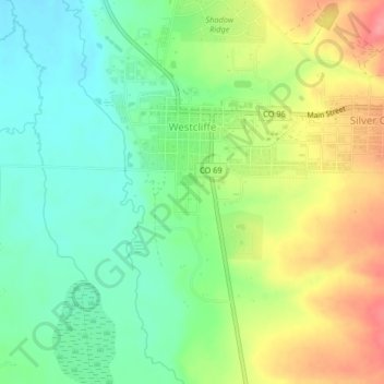
Name: Westcliffe topographic map, elevation, terrain.

Location: Westcliffe, Custer County, Colorado, United States (38.11315 -105.47796 38.14534 -105.45817)

Average elevation: 7,887 ft

Minimum elevation: 7,776 ft

Maximum elevation: 8,051 ft

Custer County trails, hiking, mountain biking, running and outdoor activities

Other topographic maps

Click on a map to view its topography, its elevation and its terrain.

Greenwood

United States > Colorado > Custer County

Average elevation: 6,762 ft

Phantom Terrace

United States > Colorado > Custer County

Average elevation: 12,228 ft

Broken Hand Peak

United States > Colorado > Custer County

Average elevation: 12,326 ft

Hermit Peak

United States > Colorado > Custer County

Average elevation: 12,290 ft

Gear up for your next adventure:

👟Men's Trail Runners - Lightweight footwear for fast-paced exploration and light hiking
🎒Gear Packing Cubes - Organize your backpack efficiently
🧷Carabiner Set - Durable clips for gear attachment
Solar GPS Watches - Advanced multisport watches with built-in topographic maps
🪵Folding Camp Saw - Compact saw for wood and campsite work

As an Amazon Associate, this site earns from qualifying purchases at no extra cost to you.