
Thank you for supporting this site ❤️
Make a donation
Make a donation
Gear up for your next adventure:
As an Amazon Associate, this site earns from qualifying purchases at no extra cost to you.
Sơn La topographic map
Click on the map to display elevation.
Thank you for supporting this site ❤️
Make a donation
Make a donation
Gear up for your next adventure:
As an Amazon Associate, this site earns from qualifying purchases at no extra cost to you.
About this map
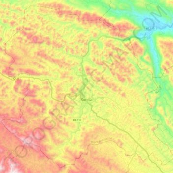
Name: Sơn La topographic map, elevation, terrain.
Location: Sơn La, Sơn La Province, Vietnam (21.24458 103.80298 21.44167 104.02903)
Average elevation: 2,352 ft
Minimum elevation: 472 ft
Maximum elevation: 4,337 ft
Thank you for supporting this site ❤️
Make a donation
Make a donation
Gear up for your next adventure:
As an Amazon Associate, this site earns from qualifying purchases at no extra cost to you.
Other topographic maps
Click on a map to view its topography, its elevation and its terrain.
Chieng khoa watefall
Vietnam > Son La province > Vân Hồ District > Mường Khoa
Average elevation: 1,273 ft