Geolocate

Gamsha topographic map

Click on the map to display elevation.

About this map

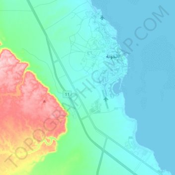
Name: Gamsha topographic map, elevation, terrain.

Location: Gamsha, Red Sea, 84513, Egypt (27.31082 33.61519 27.44024 33.70757)

Average elevation: 154 ft

Minimum elevation: -13 ft

Maximum elevation: 794 ft

Other topographic maps

Click on a map to view its topography, its elevation and its terrain.

Gulf of Suez

Egypt > Red Sea

Average elevation: 1,578 ft

Abu Ghusun

Egypt > Red Sea

Average elevation: 46 ft

Sharm El Luli

Egypt > Red Sea

Average elevation: 33 ft

Gabal Elba

Egypt > Red Sea

Average elevation: 3,294 ft

Gharib Cape

Egypt > Red Sea

Average elevation: 180 ft

Ash Shalatin

Egypt > Red Sea

Average elevation: 102 ft

Gear up for your next adventure:

🖼️Topo Map Wall Art - Decorative topographic prints of famous peaks and regions
🔭Compact Binoculars - HD vision for scouting terrain and identifying distant landmarks
🥘Titanium Cookware - Durable, featherlight pots and pans for backpacking
🧷Carabiner Set - Durable clips for gear attachment
🔦Powerful Headlamps - Ultra-bright hands-free lighting for night navigation

As an Amazon Associate, this site earns from qualifying purchases at no extra cost to you.