Geolocate

Paupack topographic map

Click on the map to display elevation.

About this map

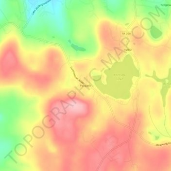
Name: Paupack topographic map, elevation, terrain.

Location: Paupack, Pike County, Pennsylvania, 18464, United States (41.37620 -75.21629 41.41620 -75.17629)

Average elevation: 1,539 ft

Minimum elevation: 1,214 ft

Maximum elevation: 1,755 ft

Pike County trails, hiking, mountain biking, running and outdoor activities

Other topographic maps

Click on a map to view its topography, its elevation and its terrain.

Palmyra Township

United States > Pennsylvania > Pike County

Average elevation: 1,447 ft

Greene Township

United States > Pennsylvania > Pike County

Average elevation: 1,614 ft

Gear up for your next adventure:

🪶Multi‑Purpose Knife - Useful blade for camp and trail
🧯Portable Fire Pit - Compact fire pit for camping spots
🔭Telescopic Hiking Pole - Adjustable pole for hiking stability
🥤Water Filter Bottle - All‑in‑one filter bottle for safe hydration
📻Weather Alert Radios - Stay informed of storm risks while off-the-grid

As an Amazon Associate, this site earns from qualifying purchases at no extra cost to you.