Geolocate

Stetson topographic map

Click on the map to display elevation.

About this map

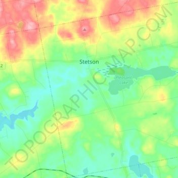
Name: Stetson topographic map, elevation, terrain.

Location: Stetson, Penobscot County, Maine, 04488, United States (44.82491 -69.18353 44.92696 -69.03921)

Average elevation: 308 ft

Minimum elevation: 180 ft

Maximum elevation: 545 ft

Penobscot County trails, hiking, mountain biking, running and outdoor activities

Other topographic maps

Click on a map to view its topography, its elevation and its terrain.

Lincoln

United States > Maine > Penobscot County > Lincoln

Average elevation: 272 ft

Houston Island

United States > Maine > Penobscot County > Winn

Average elevation: 243 ft

Carroll

United States > Maine > Penobscot County

Average elevation: 778 ft

Fairmont Park

United States > Maine > Penobscot County > Bangor

Average elevation: 148 ft

Meadow Brook

United States > Maine > Penobscot County

Average elevation: 325 ft

Gear up for your next adventure:

🧭Orienteering Set - Complete compass and map reading kit
🪶Fire Starter Kit - Reliable fire starter for survival and camping
🪶Thermal Camp Blanket - Extra warmth for cold nights
🛰️Satellite Messengers - Emergency SOS and two-way messaging for off-grid adventures
🎒Outdoor Daypacks - Lightweight backpacks designed for carrying maps and essential gear

As an Amazon Associate, this site earns from qualifying purchases at no extra cost to you.