Geolocate

Stewarton topographic map

Click on the map to display elevation.

About this map

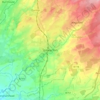
Name: Stewarton topographic map, elevation, terrain.

Location: Stewarton, East Ayrshire, Scotland, KA3 5AG, United Kingdom (55.64027 -4.55530 55.72027 -4.47530)

Average elevation: 387 ft

Minimum elevation: 121 ft

Maximum elevation: 761 ft

Other topographic maps

Click on a map to view its topography, its elevation and its terrain.

Glenbuck Loch

United Kingdom > Scotland > East Ayrshire

Average elevation: 1,073 ft

River Doon

United Kingdom > Scotland > East Ayrshire > Dalrymple

Average elevation: 551 ft

River Ayr

United Kingdom > Scotland > East Ayrshire

Average elevation: 689 ft

Braid Wood

United Kingdom > Scotland > East Ayrshire

Average elevation: 374 ft

Loch Doon

United Kingdom > Scotland > East Ayrshire

Average elevation: 955 ft

Gear up for your next adventure:

📶Vehicle Signal Boosters - Improve reception in rural areas while driving to trailheads
🎁Geography Themed Gifts - Unique gift ideas for map lovers and geography enthusiasts
🪶Camp Gear Gift Set - Perfect gift bundle for outdoor fans
🔦Powerful Headlamps - Ultra-bright hands-free lighting for night navigation
🧤Hiking Gloves - Protective gloves for rugged trails

As an Amazon Associate, this site earns from qualifying purchases at no extra cost to you.