Geolocate

Cheltenham topographic map

Click on the map to display elevation.

About this map

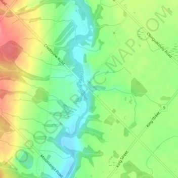
Name: Cheltenham topographic map, elevation, terrain.

Location: Cheltenham, Caledon, Peel Region, Golden Horseshoe, Ontario, L7C 1N3, Canada (43.74162 -79.93085 43.76162 -79.91085)

Average elevation: 932 ft

Minimum elevation: 830 ft

Maximum elevation: 1,063 ft

Other topographic maps

Click on a map to view its topography, its elevation and its terrain.

Cheltenham Badlands

Canada > Ontario > Peel Region > Caledon

Average elevation: 1,096 ft

Badlands

Canada > Ontario > Peel Region > Caledon

Average elevation: 1,122 ft

Gear up for your next adventure:

📶Satellite Messenger - Communication device off‑grid
🪶Compact Camp Shovel - Folding shovel for campsite tasks
🪶Trail Camera - Capture wildlife on your hikes
🔌Solar Panel Charger - Charge gear sustainably outdoors
👟Men's Trail Runners - Lightweight footwear for fast-paced exploration and light hiking

As an Amazon Associate, this site earns from qualifying purchases at no extra cost to you.