
Make a donation
Gear up for your next adventure:
As an Amazon Associate, this site earns from qualifying purchases at no extra cost to you.
La Bella topographic map
Click on the map to display elevation.
Make a donation
Gear up for your next adventure:
As an Amazon Associate, this site earns from qualifying purchases at no extra cost to you.
About this map
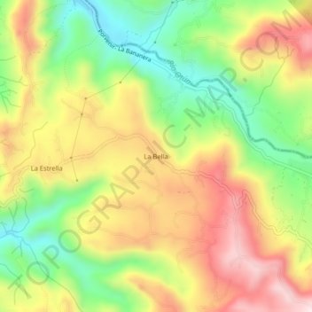
Name: La Bella topographic map, elevation, terrain.
Average elevation: 5,702 ft
Minimum elevation: 5,003 ft
Maximum elevation: 6,440 ft
Make a donation
Gear up for your next adventure:
As an Amazon Associate, this site earns from qualifying purchases at no extra cost to you.
Other topographic maps
Click on a map to view its topography, its elevation and its terrain.
Paz Del Rio
Colombia > Risaralda > AMCO, Area Metropolitana Centro Occidente
Average elevation: 4,862 ft
San Camilo
Colombia > Risaralda > AMCO, Area Metropolitana Centro Occidente
Average elevation: 4,554 ft
Villa Colombia
Colombia > Risaralda > AMCO, Area Metropolitana Centro Occidente
Average elevation: 4,610 ft
Make a donation
Gear up for your next adventure:
As an Amazon Associate, this site earns from qualifying purchases at no extra cost to you.
Nuevo Penol
Colombia > Risaralda > AMCO, Area Metropolitana Centro Occidente
Average elevation: 4,596 ft
San Martin de Loba
Colombia > Risaralda > AMCO, Area Metropolitana Centro Occidente
Average elevation: 4,521 ft
Tribunas Corcega
Colombia > Risaralda > AMCO, Area Metropolitana Centro Occidente
Average elevation: 5,043 ft
La Florida
Colombia > Risaralda > AMCO, Area Metropolitana Centro Occidente
Average elevation: 4,583 ft
Make a donation
Gear up for your next adventure:
As an Amazon Associate, this site earns from qualifying purchases at no extra cost to you.
Montelibano
Colombia > Risaralda > AMCO, Area Metropolitana Centro Occidente
Average elevation: 4,354 ft
Belalcazar
Colombia > Risaralda > AMCO, Area Metropolitana Centro Occidente
Average elevation: 4,583 ft
Make a donation
Gear up for your next adventure:
As an Amazon Associate, this site earns from qualifying purchases at no extra cost to you.
Las Brisas
Colombia > Risaralda > AMCO, Area Metropolitana Centro Occidente
Average elevation: 4,993 ft
Quebrada Dos Quebradas
Colombia > Risaralda > AMCO, Area Metropolitana Centro Occidente
Average elevation: 4,580 ft
Departamento
Colombia > Risaralda > AMCO, Area Metropolitana Centro Occidente
Average elevation: 4,285 ft
Make a donation
Gear up for your next adventure:
As an Amazon Associate, this site earns from qualifying purchases at no extra cost to you.
La Bananera
Colombia > Risaralda > AMCO, Area Metropolitana Centro Occidente
Average elevation: 5,561 ft
Monserrate
Colombia > Risaralda > AMCO, Area Metropolitana Centro Occidente
Average elevation: 4,941 ft
Andalucia
Colombia > Risaralda > AMCO, Area Metropolitana Centro Occidente
Average elevation: 4,367 ft
Las Gaviotas
Colombia > Risaralda > AMCO, Area Metropolitana Centro Occidente
Average elevation: 4,590 ft
Make a donation
Gear up for your next adventure:
As an Amazon Associate, this site earns from qualifying purchases at no extra cost to you.
Villa Colombia
Colombia > Risaralda > AMCO, Area Metropolitana Centro Occidente
Average elevation: 4,610 ft
Villa Colombia
Colombia > Risaralda > AMCO, Area Metropolitana Centro Occidente
Average elevation: 4,610 ft
Make a donation
Gear up for your next adventure:
As an Amazon Associate, this site earns from qualifying purchases at no extra cost to you.
Villa Colombia
Colombia > Risaralda > AMCO, Area Metropolitana Centro Occidente
Average elevation: 4,610 ft
Tres Esquinas
Colombia > Risaralda > AMCO, Area Metropolitana Centro Occidente
Average elevation: 4,190 ft
Make a donation
Gear up for your next adventure:
As an Amazon Associate, this site earns from qualifying purchases at no extra cost to you.
Villa Ligia
Colombia > Risaralda > AMCO, Area Metropolitana Centro Occidente
Average elevation: 4,285 ft
Universidad
Colombia > Risaralda > AMCO, Area Metropolitana Centro Occidente
Average elevation: 4,692 ft
La Florida
Colombia > Risaralda > AMCO, Area Metropolitana Centro Occidente
Average elevation: 4,583 ft
Make a donation
Gear up for your next adventure:
As an Amazon Associate, this site earns from qualifying purchases at no extra cost to you.