
Make a donation
Gear up for your next adventure:
As an Amazon Associate, this site earns from qualifying purchases at no extra cost to you.
Cedritos topographic map
Click on the map to display elevation.
Make a donation
Gear up for your next adventure:
As an Amazon Associate, this site earns from qualifying purchases at no extra cost to you.
About this map
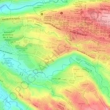
Name: Cedritos topographic map, elevation, terrain.
Average elevation: 4,413 ft
Minimum elevation: 4,137 ft
Maximum elevation: 4,636 ft
Make a donation
Gear up for your next adventure:
As an Amazon Associate, this site earns from qualifying purchases at no extra cost to you.
Other topographic maps
Click on a map to view its topography, its elevation and its terrain.
Caimalito
Colombia > Risaralda > AMCO, Area Metropolitana Centro Occidente
Average elevation: 2,959 ft
Nuevo Sol
Colombia > Risaralda > AMCO, Area Metropolitana Centro Occidente
Average elevation: 4,180 ft
Make a donation
Gear up for your next adventure:
As an Amazon Associate, this site earns from qualifying purchases at no extra cost to you.
El Chocho
Colombia > Risaralda > AMCO, Area Metropolitana Centro Occidente
Average elevation: 5,276 ft
Crucero de Combia
Colombia > Risaralda > AMCO, Area Metropolitana Centro Occidente
Average elevation: 4,154 ft
Make a donation
Gear up for your next adventure:
As an Amazon Associate, this site earns from qualifying purchases at no extra cost to you.
Alto Cerritos
Colombia > Risaralda > AMCO, Area Metropolitana Centro Occidente
Average elevation: 3,835 ft
Quebrada Dos Quebradas
Colombia > Risaralda > AMCO, Area Metropolitana Centro Occidente
Average elevation: 4,580 ft
Cañaveral
Colombia > Risaralda > AMCO, Area Metropolitana Centro Occidente
Average elevation: 4,603 ft
Altagracia
Colombia > Risaralda > AMCO, Area Metropolitana Centro Occidente
Average elevation: 4,833 ft
Make a donation
Gear up for your next adventure:
As an Amazon Associate, this site earns from qualifying purchases at no extra cost to you.