
Make a donation
Gear up for your next adventure:
As an Amazon Associate, this site earns from qualifying purchases at no extra cost to you.
Pisgah topographic map
Click on the map to display elevation.
Make a donation
Gear up for your next adventure:
As an Amazon Associate, this site earns from qualifying purchases at no extra cost to you.
About this map
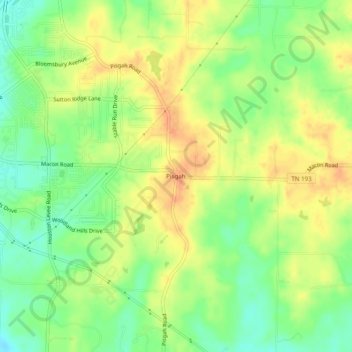
Name: Pisgah topographic map, elevation, terrain.
Average elevation: 354 ft
Minimum elevation: 285 ft
Maximum elevation: 413 ft
Make a donation
Gear up for your next adventure:
As an Amazon Associate, this site earns from qualifying purchases at no extra cost to you.
Other topographic maps
Click on a map to view its topography, its elevation and its terrain.
Memphis
United States > Tennessee > Shelby County
Memphis is characterized by a varied topography shaped by its location on the Chickasaw Bluffs overlooking the Mississippi River. The city itself sits at an elevation of about 300 feet, providing a scenic view of the river valley below. To the west, the landscape transitions into the Mississippi Alluvial…
Average elevation: 282 ft
Make a donation
Gear up for your next adventure:
As an Amazon Associate, this site earns from qualifying purchases at no extra cost to you.
Shelby Farms Park
United States > Tennessee > Shelby County > Memphis > Cordova
Average elevation: 295 ft
Make a donation
Gear up for your next adventure:
As an Amazon Associate, this site earns from qualifying purchases at no extra cost to you.
Shelby Farms Park
United States > Tennessee > Shelby County > Memphis > Cordova
Average elevation: 295 ft
North Forrest bend beach
United States > Tennessee > Shelby County > Collierville
Average elevation: 299 ft
Make a donation
Gear up for your next adventure:
As an Amazon Associate, this site earns from qualifying purchases at no extra cost to you.
Make a donation
Gear up for your next adventure:
As an Amazon Associate, this site earns from qualifying purchases at no extra cost to you.
Make a donation
Gear up for your next adventure:
As an Amazon Associate, this site earns from qualifying purchases at no extra cost to you.