Geolocate

Dillon topographic map

Click on the map to display elevation.

Dillon

Dillon is located at 45°12′57″N 112°38′3″W / 45.21583°N 112.63417°W / 45.21583; -112.63417 (45.215735, -112.634055), approximately 40 miles (64 km) east of the Continental Divide. It lies at an elevation of 5,102 feet (1,555 m).

Wikipedia (CC-BY-SA 3.0)

About this map

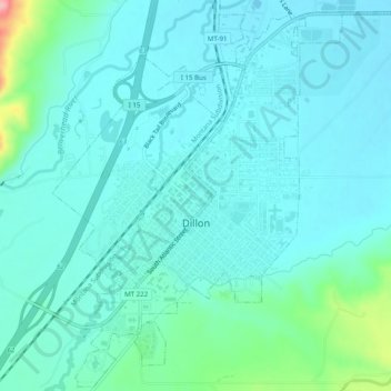
Name: Dillon topographic map, elevation, terrain.

Location: Dillon, Beaverhead County, Montana, United States (45.19960 -112.65274 45.23354 -112.60351)

Average elevation: 5,125 ft

Minimum elevation: 5,056 ft

Maximum elevation: 5,476 ft

Beaverhead County trails, hiking, mountain biking, running and outdoor activities

Other topographic maps

Click on a map to view its topography, its elevation and its terrain.

Clark Canyon Dam

United States > Montana > Beaverhead County

Average elevation: 5,666 ft

Polaris

United States > Montana > Beaverhead County

Average elevation: 6,614 ft

Monida

United States > Montana > Beaverhead County

Average elevation: 6,926 ft

Red Rock River

United States > Montana > Beaverhead County > Dell

Average elevation: 6,017 ft

Polaris

United States > Montana > Beaverhead County

Average elevation: 6,614 ft

Kidd

United States > Montana > Beaverhead County

Average elevation: 5,879 ft

Polaris

United States > Montana > Beaverhead County

Average elevation: 6,614 ft

Jackson

United States > Montana > Beaverhead County

Average elevation: 6,545 ft

Ski Hill

United States > Montana > Beaverhead County

Average elevation: 7,267 ft

Gear up for your next adventure:

🩹Survival Bandages - High‑quality bandages for emergencies
☀️Outdoor Sunscreen - High protection sunscreen for outdoor activities
🔭Compact Binoculars - HD vision for scouting terrain and identifying distant landmarks
🚪Portable Camp Chair - Foldable chair for comfort at camp
📷Action Cameras - Rugged cameras to document your journeys across rugged terrain

As an Amazon Associate, this site earns from qualifying purchases at no extra cost to you.