
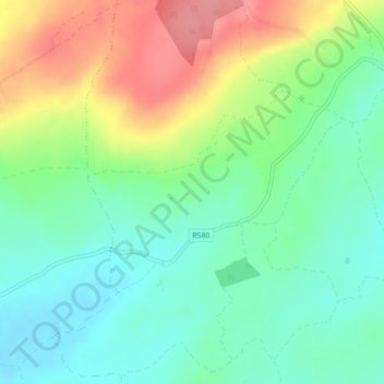
Curraglass topographic map
Interactive map
Click on the map to display elevation.
About this map
Name: Curraglass topographic map, elevation, terrain.
Average elevation: 443 ft
Minimum elevation: 331 ft
Maximum elevation: 630 ft
Other topographic maps
Click on a map to view its topography, its elevation and its terrain.
Cork
Ireland > County Cork > Cork
Cork, County Cork, Munster, T12 T997, Ireland
Average elevation: 308 ft
Shanagarry
Shanagarry, The Municipal District of East Cork, County Cork, Munster, P25 HX82, Ireland
Average elevation: 46 ft
Ardnahinch
Ardnahinch, Ballycottin ED, The Municipal District of East Cork, County Cork, Munster, Ireland
Average elevation: 16 ft
Bandon
Bandon, The Municipal District of Bandon-Kinsale, County Cork, Munster, Ireland
Average elevation: 194 ft
Meelin
Meelin, The Municipal District of Kanturk-Mallow, County Cork, Munster, Ireland
Average elevation: 807 ft
Kilgobbin
Kilgobbin, Ballinadee ED, The Municipal District of Bandon-Kinsale, County Cork, Munster, Ireland
Average elevation: 279 ft
Ballincollig
Ireland > County Cork > Cork
Ballincollig, Cork, County Cork, Munster, P31 TW88, Ireland
Average elevation: 203 ft
Inchigeelagh
Inchigeelagh, Municipal District of Macroom, County Cork, Munster, P12 W864, Ireland
Average elevation: 443 ft
Knockawaddra
Knockawaddra, Ballingurteen ED, West Cork, County Cork, Munster, Ireland
Average elevation: 505 ft
Coolmore Cross
Coolmore Cross, Carrigaline ED, Municipal District of Carrigaline, County Cork, Munster, P43 DA03, Ireland
Average elevation: 69 ft
Killeagh
Killeagh, The Municipal District of East Cork, County Cork, Munster, P36 KN61, Ireland
Average elevation: 105 ft
Gortroe
Gortroe, The Municipal District of Fermoy, County Cork, Munster, P61 TD96, Ireland
Average elevation: 394 ft
Lyre
Lyre, Tincoora, The Municipal District of Kanturk-Mallow, County Cork, Munster, Ireland
Average elevation: 702 ft
Water-rock
Water-rock, Carrigtohill ED, Municipal District of Cobh, County Cork, Munster, Ireland
Average elevation: 72 ft
Castletownroche
Castletownroche, The Municipal District of Fermoy, County Cork, Munster, P51 K064, Ireland
Average elevation: 220 ft
Dundareirke
Dundareirke, Kilnamartery, Municipal District of Macroom, County Cork, Munster, Ireland
Average elevation: 381 ft
Castlemartyr
Castlemartyr, The Municipal District of East Cork, County Cork, Munster, Ireland
Average elevation: 46 ft
Ballincollig Regional Park
Ireland > County Cork > Cork
Ballincollig Regional Park, West Village, Carrigrohane Beg ED, Cork, County Cork, Munster, Ireland
Average elevation: 180 ft
Berrings
Berrings, Dripsey, Municipal District of Macroom, County Cork, Munster, Ireland
Average elevation: 371 ft
Moneyreague
Moneyreague, Coolmountain ED, West Cork, County Cork, Munster, Ireland
Average elevation: 400 ft
Macroom
Macroom, Municipal District of Macroom, County Cork, Munster, Ireland
Average elevation: 361 ft
Waterfall
Waterfall, Inishkenny, Municipal District of Carrigaline, County Cork, Munster, T12 CYF2, Ireland
Average elevation: 315 ft
Ballymore
Ballymore, Cobh Rural ED, Municipal District of Cobh, County Cork, Munster, Ireland
Average elevation: 131 ft
Aghabullogue
Aghabullogue, Municipal District of Macroom, County Cork, Munster, P12 DY92, Ireland
Average elevation: 436 ft
Liscahane Beg
Liscahane Beg, Kinsale Rural, The Municipal District of Bandon-Kinsale, County Cork, Munster, Ireland
Average elevation: 154 ft
Kilmurry
Kilmurry, Municipal District of Macroom, County Cork, Munster, P14 R940, Ireland
Average elevation: 400 ft
Mallow
Mallow, The Municipal District of Kanturk-Mallow, County Cork, Munster, Ireland
Average elevation: 253 ft
Baltimore
Baltimore, West Cork, County Cork, Munster, P81 F623, Ireland
Average elevation: 75 ft
Kilmacsimon
Kilmacsimon, Knockroe, The Municipal District of Bandon-Kinsale, County Cork, Munster, Ireland
Average elevation: 164 ft
Timoleague
Timoleague, The Municipal District of Bandon-Kinsale, County Cork, Munster, P72 DX23, Ireland
Average elevation: 157 ft
Dromsarane
Dromsarane, Castlemartyr ED, The Municipal District of East Cork, County Cork, Munster, Ireland
Average elevation: 177 ft
Glounthaune
Glounthaune, Municipal District of Cobh, County Cork, Munster, T45 V201, Ireland
Average elevation: 171 ft
Tawnies Lower
Tawnies Lower, Clonakilty Urban ED, West Cork, County Cork, Munster, Ireland
Average elevation: 151 ft
Ladysbridge
Ladysbridge, Ightermurragh, The Municipal District of East Cork, County Cork, Munster, P25 X820, Ireland
Average elevation: 98 ft
Ringcurran
Ringcurran, The Municipal District of Bandon-Kinsale, County Cork, Munster, Ireland
Average elevation: 197 ft
Ardamadane
Ireland > County Cork > Cork
Ardamadane, Blarney ED, Cork, County Cork, Munster, Ireland
Average elevation: 302 ft
Doneraile
Doneraile, The Municipal District of Fermoy, County Cork, Munster, Ireland
Average elevation: 279 ft
Kilmaclenine
Kilmaclenine, The Municipal District of Kanturk-Mallow, County Cork, Munster, Ireland
Average elevation: 358 ft
Dunbulloge
Dunbulloge, Killeagh, Municipal District of Cobh, County Cork, Munster, Ireland
Average elevation: 384 ft
Ringrone
Ringrone, Kinsale Rural, The Municipal District of Bandon-Kinsale, County Cork, Munster, Ireland
Average elevation: 135 ft
Monkstown
Ireland > County Cork > Municipal District of Carrigaline
Monkstown, Municipal District of Carrigaline, County Cork, Munster, T12 KT5N, Ireland
Average elevation: 144 ft
Aghada
Aghada, Corkbeg ED, The Municipal District of East Cork, County Cork, Munster, P25 HX04, Ireland
Average elevation: 82 ft
Halfway
Halfway, Dunderrow, Municipal District of Carrigaline, County Cork, Munster, T12 KT99, Ireland
Average elevation: 315 ft
Cloghmacow
Cloghmacow, Warrenscourt, Municipal District of Macroom, County Cork, Munster, Ireland
Average elevation: 387 ft
Roughgrove East
Roughgrove East, Kilbrogan, The Municipal District of Bandon-Kinsale, County Cork, Munster, Ireland
Average elevation: 344 ft
Banteer
Banteer, The Municipal District of Kanturk-Mallow, County Cork, Munster, Ireland
Average elevation: 279 ft