
Seattle topographic map
Click on the map to display elevation.
Seattle
Seattle features a diverse topography characterized by its unique geographical setting between Puget Sound and Lake Washington. The city is situated on an isthmus, which contributes to its dramatic landscape, featuring rolling hills and steep slopes that rise abruptly from the waterfront. The average elevation in Seattle is approximately 131 feet, with the highest point reaching around 520 feet above sea level at areas like Beacon Hill. The terrain is punctuated by numerous valleys and ridges, making it visually striking and providing expansive views of both the Olympic Mountains to the west and the Cascade Range to the east. The presence of water bodies and the varying elevations create a lush environment, supporting diverse ecosystems and offering ample recreational opportunities, from hiking in nearby forests to boating on the lakes.
About this map
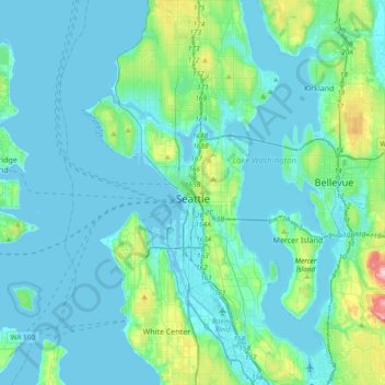
Name: Seattle topographic map, elevation, terrain.
Location: Seattle, King County, Washington, United States (47.48100 -122.45970 47.73415 -122.22443)
Average elevation: 131 ft
Minimum elevation: -20 ft
Maximum elevation: 1,050 ft
King County trails, hiking, mountain biking, running and outdoor activities
Other topographic maps
Click on a map to view its topography, its elevation and its terrain.
Mount Si
United States > Washington > King County
The peak can be accessed by two trails. The Old Mount Si trail is accessed by the Little Si parking lot and the Boulder Garden Loop. It is 0.6 miles (0.97 km) shorter, 270 feet (82 m) steeper in elevation gain, and less crowded than the main trail. The Mount Si trail is accessed by the Mount Si parking lot.
Average elevation: 2,602 ft
West Hylebos Wetlands Park
United States > Washington > King County > Federal Way
Average elevation: 276 ft
Stevens Pass
United States > Washington > King County
Stevens Pass (elevation 4,061 ft (1,238 m)) is a mountain pass through the Cascade Mountains located at the border of King County and Chelan County in Washington, United States. U.S. Route 2 travels over the pass, reaching a maximum elevation of 4,061 feet (1,238 m). The Pacific Crest Trail crosses the highway…
Average elevation: 4,551 ft
Preston
United States > Washington > King County
Preston is a historic mill town on the northeast edge of the large Tiger Mountain State Forest, along Interstate 90. Preston, elevation 430 ft (130 m), is located within commuting distance of Seattle and Bellevue.
Average elevation: 886 ft
Hot Springs
United States > Washington > King County
Hot Springs is located east of Enumclaw and just west of Lester, along the Green River and BNSF Railway line. Its elevation is 1512 feet (460m) above sea level.
Average elevation: 1,929 ft
Stampede Pass
United States > Washington > King County
Stampede Pass (elevation 3,672 feet (1,119 m)) is a mountain pass in the northwest United States, through the Cascade Range in Washington. Southeast of Seattle and east of Tacoma, its importance to transportation lies almost entirely with railroading, as no paved roads cross it. It is approximately twelve…
Average elevation: 3,724 ft
Mercer Island
United States > Washington > King County > Mercer Island
Mercer Island City Hall is located at 47°34′39″N 122°12′43.2″W / 47.57750°N 122.212000°W / 47.57750; -122.212000 (47.5775, -122.212). The peak elevation in the city is about 338 feet (103 m), near the center of the island.
Average elevation: 128 ft
Mount Index
United States > Washington > King County
Mount Index is a peak in the central part of the Cascade Range of Washington state. It lies just south of the Skykomish River and U.S. Route 2, at the western edge of the Cascades. Despite its low elevation relative to peaks higher in the Cascades, it is a famous and dramatic landmark due to its topographic…
Average elevation: 3,865 ft
Mount Si
United States > Washington > King County
The peak can be accessed by two trails. The Old Mount Si trail is accessed by the Little Si parking lot and the Boulder Garden Loop. It is 0.6 miles (0.97 km) shorter, 270 feet (82 m) steeper in elevation gain, and less crowded than the main trail. The Mount Si trail is accessed by the Mount Si parking lot.
Average elevation: 2,582 ft
Maple Valley
United States > Washington > King County > Maple Valley > Maple Valley
Average elevation: 545 ft
Lester
United States > Washington > King County
Lester is located, east of Enumclaw, Washington along the Green River and BNSF Railway line. Its elevation is 1,634 feet (498 m) above sea level.
Average elevation: 2,264 ft
Hot Springs
United States > Washington > King County
Hot Springs is located east of Enumclaw and just west of Lester, along the Green River and BNSF Railway line. Its elevation is 1512 feet (460m) above sea level.
Average elevation: 1,929 ft
Mount Si
United States > Washington > King County
The peak can be accessed by two trails. The Old Mount Si trail is accessed by the Little Si parking lot and the Boulder Garden Loop. It is 0.6 miles (0.97 km) shorter, 270 feet (82 m) steeper in elevation gain, and less crowded than the main trail. The Mount Si trail is accessed by the Mount Si parking lot.
Average elevation: 2,582 ft
Asian Small-Clawed Otters
United States > Washington > King County > Seattle
Average elevation: 203 ft
Lake Forest Park
United States > Washington > King County > Lake Forest Park > Lake Forest Park
Average elevation: 279 ft