
Make a donation
Gear up for your next adventure:
As an Amazon Associate, this site earns from qualifying purchases at no extra cost to you.
West Boylston topographic map
Click on the map to display elevation.
Make a donation
Gear up for your next adventure:
As an Amazon Associate, this site earns from qualifying purchases at no extra cost to you.
About this map
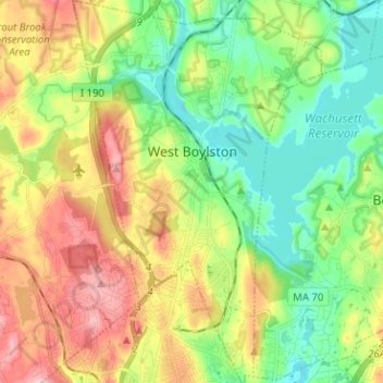
Name: West Boylston topographic map, elevation, terrain.
Average elevation: 571 ft
Minimum elevation: 364 ft
Maximum elevation: 883 ft
Worcester County trails, hiking, mountain biking, running and outdoor activities
Make a donation
Gear up for your next adventure:
As an Amazon Associate, this site earns from qualifying purchases at no extra cost to you.
Other topographic maps
Click on a map to view its topography, its elevation and its terrain.
South Lancaster
United States > Massachusetts > Worcester County > Lancaster
Average elevation: 328 ft
Make a donation
Gear up for your next adventure:
As an Amazon Associate, this site earns from qualifying purchases at no extra cost to you.
Make a donation
Gear up for your next adventure:
As an Amazon Associate, this site earns from qualifying purchases at no extra cost to you.
Make a donation
Gear up for your next adventure:
As an Amazon Associate, this site earns from qualifying purchases at no extra cost to you.
South Royalston
United States > Massachusetts > Worcester County > Royalston
Average elevation: 942 ft
Make a donation
Gear up for your next adventure:
As an Amazon Associate, this site earns from qualifying purchases at no extra cost to you.
Gates Crossing
United States > Massachusetts > Worcester County > Leominster
Average elevation: 407 ft
Tufts
United States > Massachusetts > Worcester County > Harvard > Camp Green Eyrie
Average elevation: 384 ft
Make a donation
Gear up for your next adventure:
As an Amazon Associate, this site earns from qualifying purchases at no extra cost to you.
Make a donation
Gear up for your next adventure:
As an Amazon Associate, this site earns from qualifying purchases at no extra cost to you.
Windmere Drive
United States > Massachusetts > Worcester County > Southborough
Average elevation: 312 ft
South Ashburnham
United States > Massachusetts > Worcester County > Ashburnham
Average elevation: 1,056 ft
Make a donation
Gear up for your next adventure:
As an Amazon Associate, this site earns from qualifying purchases at no extra cost to you.
Teneriffe Hill
United States > Massachusetts > Worcester County > East Brookfield
Average elevation: 659 ft
Make a donation
Gear up for your next adventure:
As an Amazon Associate, this site earns from qualifying purchases at no extra cost to you.
North Worcester
United States > Massachusetts > Worcester County > Worcester
Average elevation: 709 ft
Pinedale
United States > Massachusetts > Worcester County > Athol > Pinedale
Average elevation: 686 ft
Marks Garrison
United States > Massachusetts > Worcester County > West Brookfield
Average elevation: 673 ft
Make a donation
Gear up for your next adventure:
As an Amazon Associate, this site earns from qualifying purchases at no extra cost to you.
Hovey Dam
United States > Massachusetts > Worcester County > Grafton > North Grafton
Average elevation: 381 ft
East Village
United States > Massachusetts > Worcester County > Webster > East Village
Average elevation: 522 ft
Grand View Estates
United States > Massachusetts > Worcester County > Dudley
Average elevation: 568 ft
Make a donation
Gear up for your next adventure:
As an Amazon Associate, this site earns from qualifying purchases at no extra cost to you.
Shrewsbury Street
United States > Massachusetts > Worcester County > Worcester
Average elevation: 538 ft
Beverly Road
United States > Massachusetts > Worcester County > Worcester > Beverly Road
Average elevation: 571 ft
Bullardville
United States > Massachusetts > Worcester County > Winchendon > Bullardville
Average elevation: 951 ft
North Rutland
United States > Massachusetts > Worcester County > Rutland > North Rutland
Average elevation: 942 ft
Make a donation
Gear up for your next adventure:
As an Amazon Associate, this site earns from qualifying purchases at no extra cost to you.
Farnumsville
United States > Massachusetts > Worcester County > Grafton > Farnumsville
Average elevation: 417 ft
Make a donation
Gear up for your next adventure:
As an Amazon Associate, this site earns from qualifying purchases at no extra cost to you.