Geolocate

Arrowhead topographic map

Click on the map to display elevation.

About this map

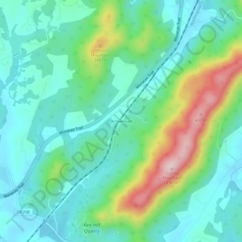
Name: Arrowhead topographic map, elevation, terrain.

Location: Arrowhead, Albemarle County, Virginia, United States (37.95931 -78.61418 37.99931 -78.57418)

Average elevation: 840 ft

Minimum elevation: 561 ft

Maximum elevation: 1,617 ft

Albemarle County trails, hiking, mountain biking, running and outdoor activities

Other topographic maps

Click on a map to view its topography, its elevation and its terrain.

Crozet

United States > Virginia > Albemarle County > Crozet

Average elevation: 682 ft

Free Union

United States > Virginia > Albemarle County > Free Union

Average elevation: 518 ft

Keswick

United States > Virginia > Albemarle County > Keswick

Average elevation: 417 ft

Rio

United States > Virginia > Albemarle County > Rio

Average elevation: 489 ft

Scottsville

United States > Virginia > Albemarle County

Average elevation: 377 ft

Ivy

United States > Virginia > Albemarle County

Average elevation: 614 ft

Rio

United States > Virginia > Albemarle County > Rio

Average elevation: 489 ft

Lake

United States > Virginia > Albemarle County > Hollymead

Average elevation: 495 ft

Crozet

United States > Virginia > Albemarle County > Crozet

Average elevation: 682 ft

Gear up for your next adventure:

🧯Emergency Survival Kit - All‑in‑one survival essentials for the backcountry
🪶Fire Starter Kit - Reliable fire starter for survival and camping
📦Dry Bags Set - Waterproof storage for electronics and clothes
🧺Microfiber Travel Towels - Compact and fast-drying towels for trail use
🧥Waterproof Jacket for Hiking - Breathable and rugged rain jacket for outdoor excursions

As an Amazon Associate, this site earns from qualifying purchases at no extra cost to you.