
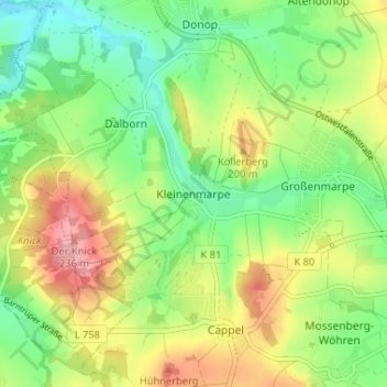
Kleinenmarpe topographic map
Interactive map
Click on the map to display elevation.
About this map
Name: Kleinenmarpe topographic map, elevation, terrain.
Average elevation: 554 ft
Minimum elevation: 390 ft
Maximum elevation: 784 ft
Other topographic maps
Click on a map to view its topography, its elevation and its terrain.
Höntrup
Deutschland > Nordrhein-Westfalen > Kreis Lippe > Blomberg
Höntrup, Blomberg, Kreis Lippe, Nordrhein-Westfalen, Deutschland
Average elevation: 548 ft
Kleinenmarpe
Deutschland > Nordrhein-Westfalen > Kreis Lippe > Blomberg
Kleinenmarpe, Blomberg, Kreis Lippe, Nordrhein-Westfalen, Deutschland
Average elevation: 554 ft
Donop
Deutschland > Nordrhein-Westfalen > Kreis Lippe > Blomberg
Donop, Blomberg, Kreis Lippe, Nordrhein-Westfalen, Deutschland
Average elevation: 525 ft
Cappel
Deutschland > Nordrhein-Westfalen > Kreis Lippe > Blomberg > Cappel
Cappel, Blomberg, Kreis Lippe, Nordrhein-Westfalen, Deutschland
Average elevation: 587 ft
Dalborn
Deutschland > Nordrhein-Westfalen > Kreis Lippe > Blomberg > Dalborn
Dalborn, Blomberg, Kreis Lippe, Nordrhein-Westfalen, Deutschland
Average elevation: 509 ft