
Isla Santa Cruz topographic map
Click on the map to display elevation.
Isla Santa Cruz
Santa Cruz Island (Spanish pronunciation: [ˈsanta ˈkɾus]) is one of the Galápagos Islands with an area of 986 km2 (381 sq mi) and a maximum altitude of 864 metres (2,835 ft). Situated in the center of the archipelago, Santa Cruz is the second largest island after Isabela. Its capital is Puerto Ayora, the most populated urban centre in the islands. On Santa Cruz, there are some small villages, whose inhabitants work in agriculture and cattle raising.
About this map
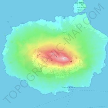
Name: Isla Santa Cruz topographic map, elevation, terrain.
Location: Isla Santa Cruz, Cantón Santa Cruz, Galápagos, Ecuador (-0.77529 -90.55007 -0.48226 -90.16878)
Average elevation: 312 ft
Minimum elevation: 0 ft
Maximum elevation: 2,815 ft
Other topographic maps
Click on a map to view its topography, its elevation and its terrain.
Isla Plaza Sur
Ecuador > Galápagos > Cantón Santa Cruz
South Plaza (Spanish: Isla Plaza Sur) is a small island off the east coast of Santa Cruz in the Galápagos Islands. It has an area of 0.13 km2 and a maximum altitude of 23 metres.
Average elevation: 16 ft
Isla Pinzón
Ecuador > Galápagos > Cantón Santa Cruz
Pinzón or Pinzon Island (Spanish: Isla Pinzón) is an island in Ecuador's Galápagos Archipelago. It has no permanent population, an area of 18 square kilometers (6.9 sq mi), and a maximum elevation of 458 meters (1,503 ft). Home to giant Galápagos tortoises of the subspecies Chelonoidis duncanensis and…
Average elevation: 407 ft