
Deira topographic map
Click on the map to display elevation.
About this map
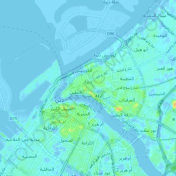
Name: Deira topographic map, elevation, terrain.
Location: Deira, Dubai, United Arab Emirates (25.23468 55.29213 25.30557 55.36026)
Average elevation: 10 ft
Minimum elevation: -49 ft
Maximum elevation: 92 ft
Other topographic maps
Click on a map to view its topography, its elevation and its terrain.
Dubai
Dubai lies directly within the Arabian Desert. However, the topography of Dubai is significantly different from that of the southern portion of the UAE in that much of Dubai's landscape is highlighted by sandy desert patterns, while gravel deserts dominate much of the southern region of the country. The sand…
Average elevation: 23 ft
Hatta
Due to Hatta's higher altitude, its climate is much cooler than central Dubai. Hatta has an arid landscape and temperature, reaching 55 degrees Celsius in the summer; however, it is less humid than Dubai and far colder in the winter.
Average elevation: 1,414 ft