Geolocate

Athens topographic map

Click on the map to display elevation.

About this map

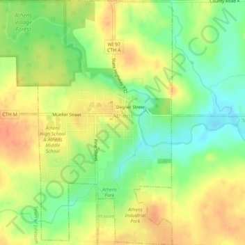
Name: Athens topographic map, elevation, terrain.

Location: Athens, Marathon County, Wisconsin, United States (45.01677 -90.09932 45.04754 -90.06512)

Average elevation: 1,378 ft

Minimum elevation: 1,299 ft

Maximum elevation: 1,447 ft

Marathon County trails, hiking, mountain biking, running and outdoor activities

Other topographic maps

Click on a map to view its topography, its elevation and its terrain.

Rib Falls

United States > Wisconsin > Marathon County

Average elevation: 1,293 ft

Ringle

United States > Wisconsin > Marathon County

Average elevation: 1,316 ft

Stack Island

United States > Wisconsin > Marathon County > Wausau

Average elevation: 1,316 ft

Rozellville

United States > Wisconsin > Marathon County

Average elevation: 1,240 ft

Gear up for your next adventure:

🚁Photography Drones - Capture stunning aerial views of landforms and topography
🪶Camping Sleeping Pad - Comfortable sleeping pad for backpacking
🛏️Cold Weather Sleeping Bag - Warm sleeping bag for cold conditions
📷Action Cameras - Rugged cameras to document your journeys across rugged terrain
🔌USB Car Charger - Car charger for on‑the‑go power needs

As an Amazon Associate, this site earns from qualifying purchases at no extra cost to you.